


 1960 1960 |
1970 |
1980 |
1990 |
 |
 |
 |
 |

 http://grid2.cr.usgs.gov/globalpop/africa/index.htm
 uwe@ncgia.ucsb.edu
Download Data

The development of this database was supported by
the United Nations Environment Programme / Global Resource Information
Database (UNEP/GRID) Sioux Falls, and the World Resources Institute
(WRI), Washington D.C. Additional support and facilities were
provided by the National Center for Geographic Information and
Analysis (NCGIA). Kim Ballasiano and Sara Moola at WRI assisted
in the compilation of population data.
The base data set described in the first part of
this documentation was compiled mostly from existing digital boundary
data sets. This would not have been possible without the generous
cooperation by many individuals at the following institutions:
This documentation describes the third version of a database of administrative units with associated population figures for Africa. The first version was compiled for UNEP's Global Desertification Atlas (UNEP 1992, Deichmann and Eklundh 1991), while the second version represented an update and expansion of this first product (Deichmann 1994, WRI 1995). The work discussed in the following paragraphs is also related to NCGIA activities to produce a global database of subnational population estimates (Tobler et al. 1995), and an improved database for the Asian continent (Deichmann 1996a).
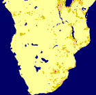
The new version for Africa provides considerably more detail: more than 4700 administrative units, compared to about 800 in the first and 2200 in the second version. In addition, for each of these units a population estimate was compiled for 1960, 70, 80 and 90 which provides an indication of past population dynamics in Africa.
As before, the database is largely a compilation of existing data sources. The institutions listed in the acknowledgments generously made digital boundary data sets available which have been integrated into the continental database. Among these, the data set obtained from the Club du Sahel's West Africa Long Term Perspective Study (WALTPS; Snrech 1995) deserves special mention. In this project, population and boundary data for nineteen countries in West Africa had been compiled (Ninnin 1994). Since these data had already been converted into a standard GIS format earlier (Brunner et al. 1995), these were directly integrated into this database. The main contribution of the project described here has been to compile all these data from different sources, put them into a consistent format, and to produce matching population figures for all but the WALTPS countries.
This third version of the database in four years was again compiled from a large number of sources (which are listed in Appendix A4). Clearly the incremental improvements made in each version highlight the fact that the compilation of a digital database of this kind needs to be seen as a process of continuous improvement rather than as a one-shot effort. There is a need for a mechanism that will incorporate new data as they become available, that ensures consistency with other sources and provides easy access to the data in terms of file formats and distribution media. Unfortunately such a mechanism is not formalized at the moment and data development therefore relies on ad hoc efforts or project-specific activities.
The following Part I of this documentation describes the development of data layers of administrative boundaries with population totals. The format of this documentation generally follows that used in the Asia database documentation (Deichmann 1996a). The following section gives general background information on data sources and estimation procedures. It also discusses data quality issues and limitations of the database which should be kept in mind in any application. Part II presents the methodology used for constructing a set of gridded data layers of population distribution. Since the same methodology was used in the construction of population distribution grids for Asia, this part of the documentation is largely identical with that for Asia. Finally, the Appendixes contain a table of summary information, the format of the attribute tables, detailed data sources and processing steps for each country.
[ Next Section | UNEP/GRID-Sioux Falls ]
<URL: http://grid2.cr.usgs.gov/globalpop/africa/index.html>
Last modified: 21 February 1997.
Please address any comments or suggestions to
webmaster@grid2.cr.usgs.gov or
uwe@ncgia.ucsb.edu.