-
 AreaSGN: Creation of signatures and spectral statistics from training areas
AreaSGN: Creation of signatures and spectral statistics from training areas| Presentation | Dialog box of the application |
| Syntax |
The training areas can be provided through a categorical raster or through a layer of polygons. The categorical raster can be obtained through applications of classification algorithms such as IsoMM, ClasSup or ClaskNN, or by rasterizing a polygon layer.
Two required input arguments must be specified. The first one is the address and the name of the input file that can be a categorical raster or a layer of polygons. And the second argument is the ASCII file with the address list of the different layers that can be from different bands of satellite images, DTM, etc. In addition, it allows to add different optional arguments, such as the creation of an HTML file with graphics of different statistics of the signatures or the creation of a CSV file with tables of statistics of the different signatures.
In case of choosing a layer of polygons to the first argument, a parameter must be included specifying the field of the DBF table that contains the class associated to each polygon. This field may be numeric or character string. If the field is numeric, you can also specify another optional parameter to indicate a field with the names of the categories.
As output parameters, you must specify the output directory of the spectral signatures. Optionally, you can ask to create an HTML file with graphics of statistics of the spectral signatures and/or a CSV file with tables of statistics of the signatures. To view the HTML file, in some browsers, such as Chrome, it is possible to export the graphic to the clipboard through the right mouse button when the cursor is on the graphic. Alternatively to these graphs, if the CSV file is opened with program such as Excel it is possible to make other graphics or customize them differently.
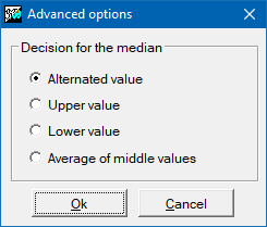
In quantile calculations, such as the median, it is possible to indicate, with the modifier /MEDIANA_EMPAT=, the type of tiebreaker to use for its calculation when the position of the quantile is between two values of the series. For more information, see general syntax.
The file with the training areas should be linked to a thesaurus table that indicates category indexes (starting with 1) in the first field and the category descriptor in the second field. It is also advisable that the file with the training areas has a suitable symbolization (typically a color symbolization table [palette]) saved in the REL file of the layer itself from the "Save" button of the dialog box in which layer display is set. This allows classification applications such as ClasSup or ClaskNN that will use the signatures (.sgn files) resulting from the execution of the AreaSGN application to automatically link the map obtained in the same category thesaurus (and when consulting any cell to obtain the category resulting from the classification) and, at the same time, the map is displayed with the appropriate colors (the same ones we have chosen for the training areas).
Note: The statistics obtained for any given variable do not necessarily match those that would be produced by masking the variable with the category of the training areas file. This is because AreaSGN computes the statistics only from the subset of the training areas that contain valid data for all variables. This requirement is necessary to ensure, for example, that the variance-covariance matrix corresponds to a real multivariate distribution (and that its inverse and determinant can, in all likelihood, be computed).

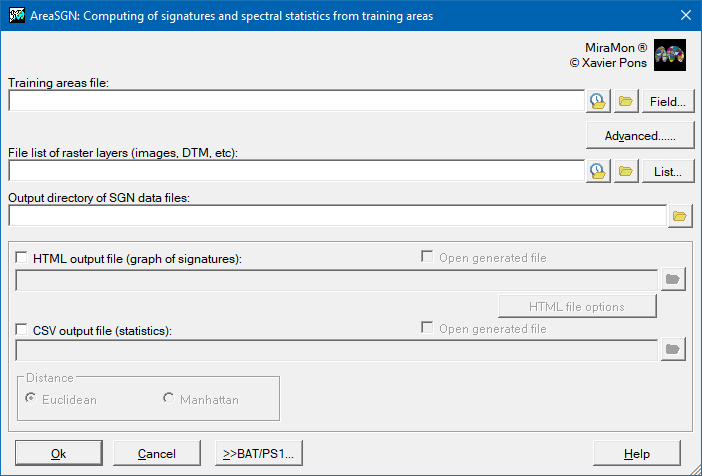  |
| AreaSGN dialog box |