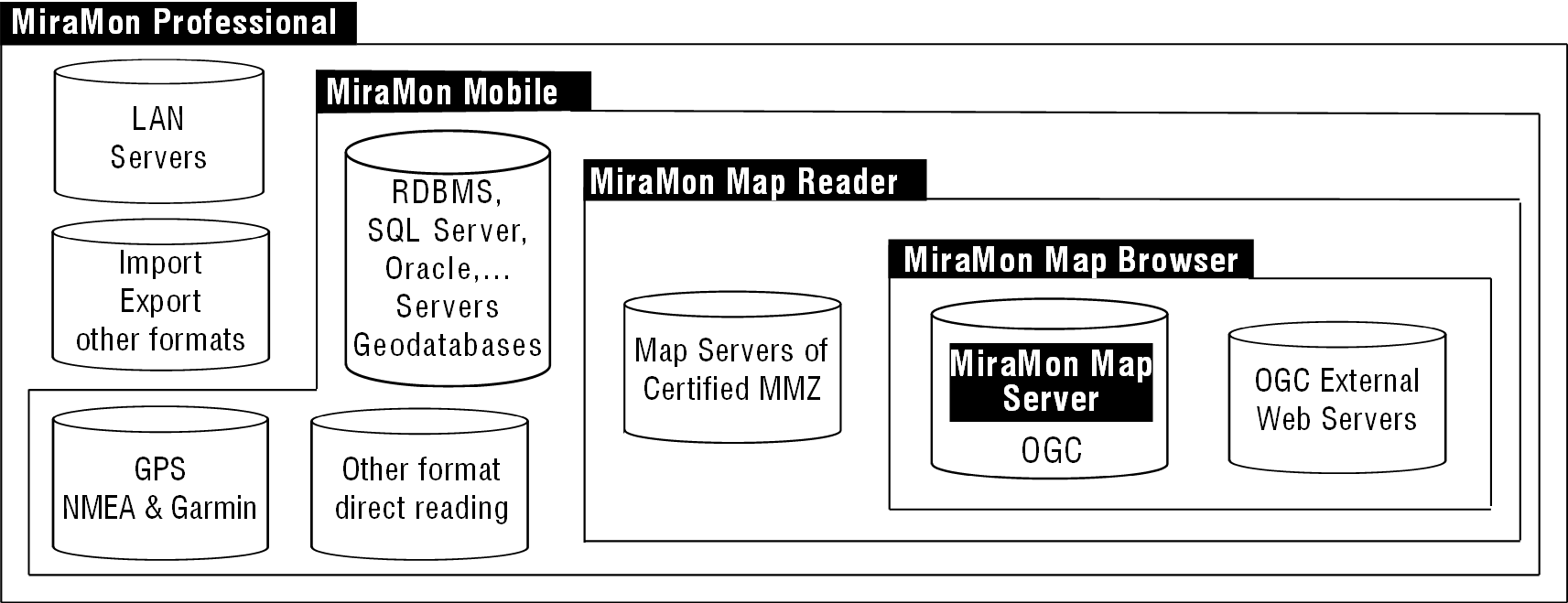
MiraMon is a Geographic Information System (GIS) and Remote
Sensing software. It allows visualization, query, edition and
analysis of raster (remote sensing images, orthophotos, digital
terrain models, conventional thematic maps with raster structure,
etc), vector (topographic and thematic maps that contain points,
lines or polygons), and WMS layers.
Some parts of the code were written from 1988, but was in 1994 when
MiraMon started to become a Windows application to be used in
scientific, educational and environmental management. The MiraMon is
developed cooperatively by various members of the Consolidated Research Group GRUMETS
belonging to the Centre for Ecological Research and Forestry Applications
(CREAF) and to the Autonomous University of Barcelona (UAB), and seeks to provide
a low cost, powerful and rigorous software.
To date is a general purpose GIS, used by around 200,000 people in
37 countries. Developed to satisfy the most common user needs it has
behind a team of expert developers in GIS and Remote Sensing working
together with final end users to improve the program daily.
Practical applications
MiraMon was chosen by the Environmental Information System in
Catalonia to distribute geographic information data on the Internet.
Its website receives around 40,000 visitors a year and was awarded a
Special Mention to the Best Science and Technology application of
the 2000 year International Internet Möbius Award. In 2007 MiraMon
team was awarded the Environmental Prize by the Department of
Environment and Housing (DMAH) of Catalonia in the form of "Research,
innovation and development."
The team members publish in the best journals of their field and
are present at the major symposiums on GIS and Remote Sensing.
Concerned about the quality mapping they are involved in defining
protocols that must shape the national cartographic scenario: they
participate in the discussion group of the Catalonian Cartographic
Plan, are editors of the Interoperability Framework of Catalonia,
collaborate in the definition of the National Remote Sensing Plan,
etc.. Internationally, they are an active member of the Open
Geospatial Consortium (OGC) where collaborate in the drafting and
revision of new standards such as WMTS of its own creation.
Most of Catalonian cartographic information is provided in
MiraMon format, among it all the official maps produced by the
Cartographic Institute of Catalonia, ICC (1:5000, 1:25000 and
1:50000 vector format topographic).
The use of MiraMon GIS software it's highly widespread in
several instances of the Catalan Administration: Environment and
Housing Department (GIS system used since 1998, all the maps
distributed in MiraMon format), Agriculture, Food and Rural Action (GIS
system of the DG Fisheries and Maritime Action since 1999), Health (Sanitary
Map of Catalonia, 2006), Catalan Water Agency (quality and quantity
water station network, calculation of nival surface), Meteorological
Service of Catalonia (risk weather situations advice maps), several
county councils, town councils (the browser of Urban Architectural
Barriers of Sabadell), museums (Museum of the History of the City of
Barcelona, Natural Science Museum), etc and in many other regions:
in the Institute of Biodiversity of Andorra (Environmental
Information Server), in the Ministry of Environment of Andorra, in
the Doñana National Park, in the Monitoring of the Protected Areas
of Spain (EUROPARC), in the Government of Aragon (the Climatic
Digital Atlas Server),...
It is used in many universities, research centers, private
consultancies, NGOs, secondary schools, etc, as well as in the
management of several natural parks. Is part of the core software in
main master and postgraduate courses in remote sensing and GIS and
it is used by over 2,000 students.
MiraMon map servers provide massive amounts of data to the
Internet or intranets. An example is the satellite image server (SatCat),
located in the Documentation Center of the DMAH that offers a free
public consultation and extraction of satellite images.
And much more existing on the way!
Applications and access to data
|
|
|
Because you can open as many layers, of any size, as the operating system allows. The complexity supported by vector layers is practically unlimited.
MiraMon manages and sup-ports a wide variety of raster data (bit, byte, short, inte-gers, long, real, 24-bit color, extracompressed, JPEG, etc) and builds real vector topo-logy.
|
|
Because a licence is not much more expensive than a university text book and Mira-Mon can run on almost any current PC. Network licences are even cheaper. Includes free updates via the Internet.
|
|
Because it is entirely written in C language,
achieving maximum performance and optimal control
program resources of the machine. It runs very fast on
network environments.
|
|
MiraMon Professional, MiraMon Map Reader and MiraMon
Map Browser/Server have received numerous national and
international awards.
|
|
They are performed periodically at CREAF and offer
different levels (see website). Specific courses can be
also organized aimed to a group of people of the same
institution or company.
|
|
|
It's the desktop application and the most powerful of them all.
Here are described some aspects of basic settings such as display,
query and print, a variety of tools for exchanging data between
formats, some topics in geometry and geodetic mapping, spatial
analysis, remote sensing tools, documentation and cataloging
metadata, use of GPS and automatic creation processes.
Visualization
For raster, vector and a combination of both, as well as with
requests from OGC WMS Layers (WMS, WMTS, WFS and WCS). It also
enables 3D visualization perspectives.
Raster. MiraMon own file formats include bit, byte, integer,
real, long, extracompressed or plain files, as well as RGB
combinations of any of them. You can directly open JPEG, JPEG2000,
JPC, J2C, MrSID, GeoTIFF, ECW, BMP, RLE, DIB and import/export PGM
or PPM, CEOs or NDF, TIFF + DIMAP of SPOT, HDF, ASCII, E00 , RST,
LAN / GIS, GRD, CTL, RF, etc formats. MiraMon treats BMP, JPEG,
MrSID and JPEG2000 files as an own format with their complete
metadata.
Vector. MiraMon own file formats may have topological
structure with the advantage that this represents: speed, connection
to databases, more complex analysis, maintaining topological
relationships (connection of islands groups, knowledge of gaps
within polygons, etc). MiraMon vector formats are: PNT, ARC, NOD,
POL and VEC. You can directly open SHP, DXF, DGN, GPX and KML format
files and tables containing x and y fields. These files can be 3D
and multi-Z for each coordinate.
Geodatabases. MiraMon allows reading and importing ESRI ArcSDE
geodatabases to MiraMon structured files preserving the Z for each
coordinate, the attributes, relational databases, etc.
Query
It allows to perform queries by location (what's in here? what's
this?) and by attributes (where is such thing? How many items meet
these criteria?) on raster and vector layers, retrieving information
directly from dBFS or from a relational database through ODBC on
MS-Access, MS SQL Server, Oracle, Informix, etc. Any field of the
database can be linked to an unlimited number of physical tables,
views, or SQL queries. WMS layers can also be interrogated by
location.
Any statistical summaries can be obtained from a query by attributes.
You can choose interactively with the mouse clicking, transects,
circles, polygons, etc., and combine these selections with queries
by attributes to obtain new statistics. The selected objects in a
query can be exported generating new specific raster or vector
layers or can be used as new selector items against another layer.
Digitizing and topology building
Allows on-screen digitizing over raster and vector layers. Can
generate layers of points, arcs and polygons. Graphic objects from
other layers can be copied directly (with or without their
attributes) in the layer being digitized.
MiraMon has several editing vector tools for connecting vertices and
segments (SNAP), partition, union, and elimination or displacement
of vertices, and the possibility of changing the attributes with a
simple click or dragging attributes from the legend.
It permits construction of a real topology on points, arcs and polygons
layers that are saved as structured binary vector. While other
software force the user to stop scanning whenever an intersection of
lines is produced, MiraMon calculates these intersections on the fly
and creates new nodes if necessary. It also allows, if desired,
dynamic topological structure digitizing!
Different polygon limits in multiple layers can be defined in a
single layer of arcs, drastically reducing the space in disk and
contributing to the consistency of the database.
It has also advanced topology tools allowing the possibility of
using tolerances: micropolygons elimination, shorten or lengthen
arcs, pseudogeneralization of lines, removal of end nodes and arcs,
etc.
GPS
Data from the GPS receiver can be acquired in two major ways: in
real time, acquiring, visualizing track and showing various
parameters of the acquisition, or later connecting the GPS receiver
to the computer.
Browse in real time with the GPS connected to the computer, allows
to be located on maps in an opened session of MiraMon and draw a
phenomenon while on the terrain. The other option allows loading and
unloading items in the case of Garmin GPS receivers (contact us for
the availability in other well-known displays). MiraMon also
directly read and import GPX format files.
More information
Cartographic geometry and geodesy
MiraMon can support and carry out conversions (of single
coordinates or whole layers) between the most common cartographic
projections, as well as datum transformations (Molodensky and
Bursa-Wolf). It can also visualize the Cartesian coordinates of the
projection (UTM X, Y, etc) and/or latitude/longitude coordinates,
reference networks and tics. It is possible to personalize new
projections and the most accurate geodesic aspects are respected
thanks to its complete model.
Satellite images and aerial photographs can be converted into
orthophotomaps using Digital Elevation Models and accurate
algorithms by means of an easy-to-use interface. The resulting
orthoimages displayed have a high degree of coincidence among
themselves and with other graphic layers. It is ideal for time
series studies based on old or recent aerial photographs or on
satellite images. These algorithms are also used to geometrically
correct digital maps scanned from paper originals.
Analysis
There are more than 80 analytical tools. Among them, the more
basic ones are the layer calculator and reclassifier that
includes reclassification and mathematical and logic operations in a
single expression and environment; and the analytical layer combination
that
allows you to combine layers and obtain new layers or tables with
crossed statistics. All these tools accept raster and/or vector
layers.
Other MiraMon tools include size pixel changes, scaling and
translating, buffers and distance maps, mosaicking and clipping
layers, 2D and 3D point or arc interpolation (trend surfaces,
inverse distance splines, kriging) to generate maps of variation (elevation
and bathymetry, temperature, pollution, etc) and terrain analysis (elevation,
slope, orientation, lighting, shading, solar radiation, etc.),
vector network analysis according to distance and travel time,
analysis of friction and travel costs, calculation of multiple
regression models, geostatistic analysis of the variogram, geometric
elementary transformations, cartographic generalization, contour
line generation, and much more. Most of these tools can work
simultaneously with raster and vector layers and take in
consideration the existence of NODATA values.
Remote Sensing
Remote sensing is present in MiraMon since the beginning. It has
specially designed tools: orthorectification of satellite images and
aerial photographs, radiometric correction, standard metadata for
sensor and platform, multiband support, unsupervised classifiers and
mixed classifiers (supervised and unsupervised), confusion matrices
generation, selective filters, calculations of emissivity and
surface temperature, and much more.
Metadata Manager and Catalogue
MiraMon incorporates two tools to ensure maximum documentation
of layers. The Manager (GeMM) which allows you to generate, edit and
save metadata, the description of the data model and relationships
between databases from a layer or a cartographic series. GeMM
conforms to INSPIRE ISO 19115 and FGDC standards. This makes it
possible to export metadata in HTML or XML format (IDEC, ISO 19139).
Unlike others, purely documentary applications, GeMM maintains
consistency by checking coherence with the datasets.
Once the map is well documented, access is easy and quick via the
Metadata Catalogue (CaMM). This is perfect when one has a large
number of maps in different locations. CaMM consists of an
application which is designed to conform with Core ISO 19115 layout
schemas and provides elements and a web interface that allows you to
carry out queries. This can be customized by means of HTML and XML
templates and is easy to use (it is not necessary to know SQL),
without losing potentiality: searches by geographical area, by
hierarchy, sensitive or not to capital letters and accents, etc.
Moreover, the creation of partial or total updating of the catalogue
can be carried out automatically.
Printing
High-quality maps of any size (A0, A1, etc) can be created
interactively and easily while maintaining total and strict control
of the map view (scale, extension, etc). Finished maps can be
printed on paper, on Enhanced Metafiles (EMF), Windows Metafiles (WMF),
high-resolution bitmaps (BMP, JPEG) or can be copied to the windows
clipboard as an EMF or WMF formats so that maps can be added to a
report.
Once they are on the clipboard, they can be pasted perfectly into
other applications (maintaining the original scale, colors and
quality of the vectors and rasters). Once a map has been composed,
it can be enlarged or reduced to fit any paper size.
Using the printing assistant, it is possible to quickly create maps
with all the most common elements (graphic and numerical scale,
north arrow, legend, date and time, etc). You can increase
productivity if you have templates created in your own style. With
advanced printing parameters and selecting personalized paper sizes
for your computer, it is possible to create large wallmaps.
|
|
|
MiraMon Professional and MiraMon Map Browser allow
direct reading of OGC-WMS, WMTS, WFS and
WCS
standards.The desktop version also supports connections
with ECWP protocol.
|
|
Are files that can open unlimited raster, vector and
WMS layers with all their properties of display and
print. They can be stored in a compressed format (MMZ):
all the information related (palettes, DBs, symbology,
etc.) into a single file!
|
|
MiraMon Professional and MiraMon Map Server can run
on Microsoft's Open Database
Connectivity technology. By this way, you will be able
to access different data sources
such as Oracle, Infomix, Access, Excel, dBase, text
files, etc.
|
|
Digitizing of boundaries of nature reserves with sub-sequent
analysis, in this case for distance, to obtain secu-rity
buffer zones.
|
|
- Conversions of angular magnitudes between degrees,
minutes, seconds and radiants.
- Geodesic calculator, which allows you to convert the
coordinates of one point from a coordinate reference
system to another coordinate system.
|
|
Among the different digital terrain models, the most frequently used are those related to elevations. The one reproduced above was obtained using vector con-tour lines, 3D lines such as rivers, etc, from topographic sheets and then interpolating them in order to generate a raster. It was subsequently shaded to make it easy to visualize the terrain.
|
|
Batch prosessing applications (BAT) can run on a
command line, building processes to execute time-consuming,
tasks, or they can be called up from one of your own
applications.
|
import/export |
|
MiraMon can easily convert between most popular GIS formats,
apart from its direct-reading: SHP, DGN, DXF, MrSID, TIFF,
JPEG2000, GPX, KML, ArcSDE, and many more. |
|
Internet, Intranet and CD-DVD Publication
|
With MiraMon you can publish your maps following one of these
technologies:
MiraMon Map Server and Browser
With this technology you can publish your maps on the Internet
and users will be able to access them via their usual web browser.
It is extremely user-friendly and makes high-quality maps available
even for very large areas. It has been developed to strictly conform
to the standards established by the Open Geospatial Consortium (formerly
known as OpenGIS).
It currently complies with Web Map Service (WMS), Web Map Tile Service (WMTS), Web Feature Service (WFS) and Web Coverage Service (WCS)
standards. It allows the user to view, zoom, pan, query by location,
go to a specific place in a predefined list, download, access
metadata, situation, create animations, etc, from one or more
MiraMon servers or from other manufacturers who support standard WMS
and WCS requests. This technology comprises a map browser, a server
application and an application to enable you to create and manage
your website.
The browser is a set of HTML files which are wholly configurable for
position, fonts and colors etc. It includes JavaScript code that is
compatible with the majority of existing browsers (Internet Explorer
5.0 or later versions, Netscape-Mozilla-Firefox 1.0 or later
versions, etc).
The server application is a CGI-type executable which can be
directly installed on a web server for Windows (Internet Information
Server, Apache, etc). It is a very light and fast executable (most
requests
are answered in less than a second). This allows for a large number
of simultaneous users.
The configuration application for the browser and the server make it
possible to set most of the browser properties through a pleasant
visual environment. It is also possible to control the layers that
the server offers.
This application is being successfully used on servers of
orthophotos, satellite images, topographical maps, thematic vector
maps, point sample maps, etc. It is also possible to access these
data via MiraMon Professional and the MiraMon Map Reader with this
technology.
WMS servers can also be used as providers of complete, real GIS
datasets, in MMZ or other formats, but using the area indicated,
with the original resolution and desired layers.
This project was initially supported by the Supercomputing Centre of
Catalonia (CESCA) as a Project of Advanced Communications. Several
digital cartography servers that use this technology can be visited
on the Internet. Other servers are part of Intranets or are
available in documentation centres.
MiraMon Map Reader
The Map Reader is a free program that allows you to view, query
and print maps published on the Internet or on CD-DVD. The maps must
have been generated by MiraMon Professional with a specific
certifying licence called MiraMon Internet Map Publisher.
Information is supplied in compressed format (MMZ), generated using
the most advanced data compression algorithms, which may contain
MiraMon maps and/or other documents. The maps, which are in digital
format, can be queried by location (clicking on any place tells us
what there is there) or by attribute (you can ask the map to find a
feature, such as a wastewater treatment plant, or a phenomenon such
as all the meteorological stations with a mean temperature of below
5ºC in January). They may be linked to other kinds of related
information, such as text documents, spreadsheets, images, graphics,
sound, HTML
pages, websites or even other maps. These may in turn be linked to
other microcosmos of information.
Works with data in both raster and vector (with or without topology)
and WMS, WMTS, etc formats.
In contrast to many other GIS available on the Internet, the
philosophy of the Map Reader does not consist in giving a simple
screenshot or a limited selection of data. It allows the data
themselves to be accessed so that the user may query and make full
use of them as often as necessary. Using this compressed format
permits a saving of both time and money, which is to the advantage
of the user and the organisation providing the data.
The Map Reader allows you to access all this information through a
simple, though not simplistic, click, which is based on a high-performance
product: the MiraMon Professional.
Data security is guaranteed by the certification included with the
compressed files (MMZ format) by the entity supplying the
information. The Map Reader checks for this certification before
displaying the data and provides the user with the name of the
certifying entity.
More information
|
|
|
Compatible HTML pages with JavaScript code (open
source).
Coordinates for current position and area. Cartesian (m)
and geographical (º) coordinates.
Layer control from legend. Automatic hide layers by
range of scales.
Links to different servers of different versions of WMS.
Transparency and semitransparency support.
Downloading of the view area in different formats.
Query by location and query by list.
Animation of temporal series
And much more...
|
standards development |
|
MiraMon team actively participates in
the development of international standards of the OGC, as the
Web Map Tile Service (WMTS), and in the review of some of them. |
|
|
MiraMon Mobile
MiraMon Mobile is an application for mobile devices (PDA, GPS
and new generation mobile phones) on Windows Mobile and Windows CE,
downloadable at www.miramon.uab.cat/mm_mobil.
Currently it allows you to read maps locally (in memory card devices)
or as WMS clients (via WiFi, 3G telephony, etc.).
If the
phone has a GPS device, its recordings can be used to control the
position of the map. The itinerary can be saved as a route and the
position always appears on the screen (as a square or an arrow
depending on the speed of movement).
New
intuitive starting interface: the collections of favourite maps.
The new
version allows MiraMon to start the session in the favourite mode
where the user can select a map from MiraMon default map collections
or from user made collections (for instance typical maps of a study
area, a project, etc).
Geographic Information Search Engine
MiraMon
new version incorporates an Internet Geographic Information search
engine among the available main data servers (MMZ, WMS, WMTS, WFS,
SHP, ECWP, etc). Users can search by means of geographic area,
thematic category, keywords, dates, etc.
Reading and importing ArcSDE geodatabases
MiraMon allows accessing ArcSDE servers. Each server may contain
one or more databases (geodatabases) that can be accessed through
the corresponding username and password. To facilitate the use of
ArcSDE geodatabases, you can structure the information in layers
containing a single type of object linked with an homogeneous
attribute table (the same type of attribute for each object layer).
|
|
|
|
Operating system
Microsoft Windows 9x /Millenium Edition / NT / 2000 / XP / 2003
Server / Vista / 7
Hardware
A Pentium processor, 16 MB memory, 300 MB hard drive, a monitor
of 800x600 pixels and 256 color graphics card is sufficient for work.
This shows that MiraMon is really small and fast: it works in old
computers and flies! in today's PCs.
Net
Runs
under Microsoft, Cytrix and Novell environments.
|
|
|
|