-
 TIFIMG: TIFF-IMG format conversion
TIFIMG: TIFF-IMG format conversion| Presentation and options | Dialog box of the application |
| Examples | Syntax |
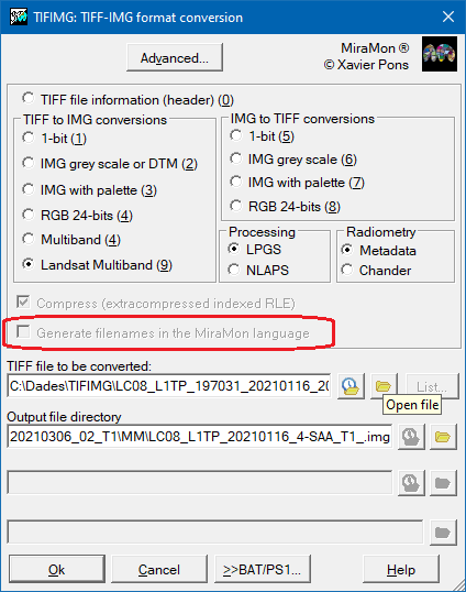
This application allows bidirectional transformation of TIFF and IMG files. In addition to its general purpose, it also allows multiband import (radiometric bands, quality, etc.) of USGS Landsat data collections 1 and 2. In the case of collection 2, both Level 1 and Level 2 processing data can be imported.
Application options:
The order in which the options are presented in this previous explanation, in the application dialog box and in the syntax corresponds to their conceptual grouping, by type of transformation (information, transformations from TIFF to the several types of IMG and from IMG to the various types of TIFF). However, the numbering of the options is correlative according to the order in which they have been programmed over the years.
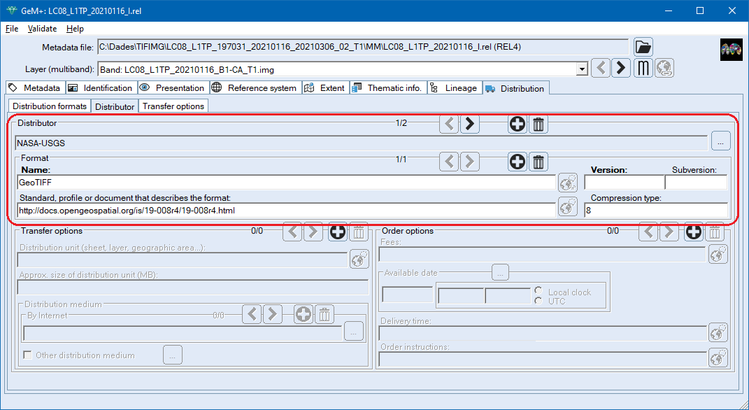
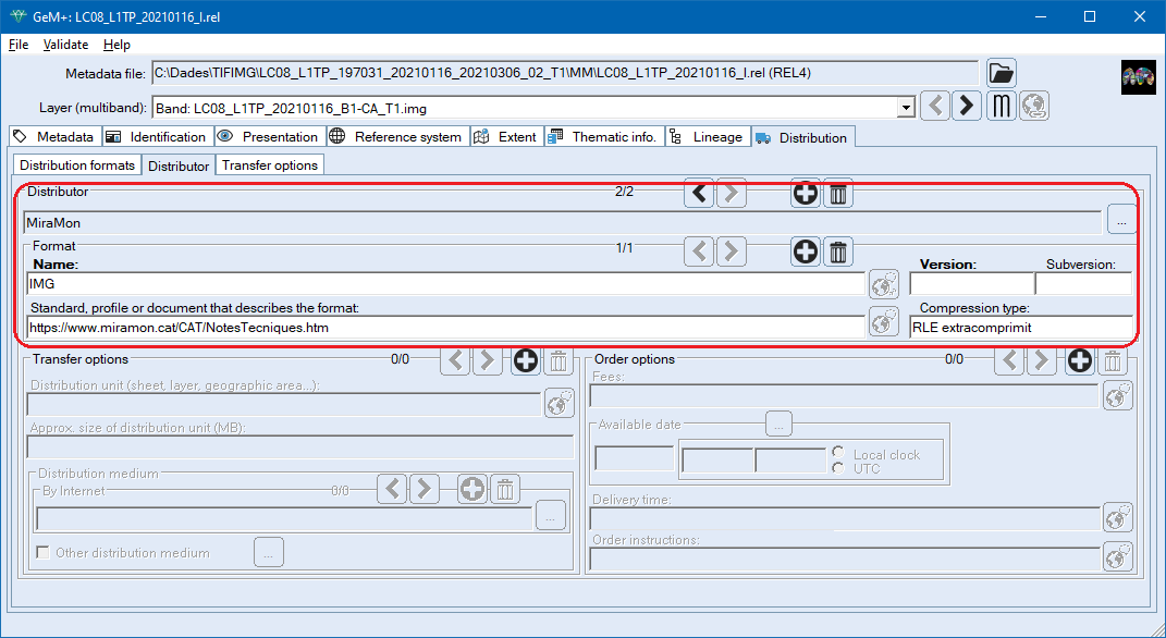
In imports of TIFF to IMG the presence of both a World file (* .TFW or * .TIFW) as of the GeoTiff format. In case of contradiction, the georeference of the World file prevails.
In IMG exports to TIFF, a GeoTiff format and a TFW.
Both the World file and the GeoTiff format allow georeference a TIFF file by assigning a pixel side and some extreme coordinates (bounding box).
In case that a TIFF file contains control points for its georeferencing, these are stored in a table with the same name than the output IMG but adding the "_GCP" suffix.
Other richest possibility in metadata is to use the DIMAP format. In In this case, the metadata is distributed in a file in XML format (from extension .dim). A file of the same name as the TIFF is supported but of extension .dim or directly a file Metadata.dim such com is distributed in a DIMAP product folder (then the TIFF file is called Imagery.tif). SPOT images are distributed this way.
More information about the DIMAP format: https://www.intelligence-airbusds.com/en/8722-the-dimap-format
More information about NLAPS and LPGS can be found through the following link, as well as in the article:
| Examples of output files from a Landsat 8 Collection 2 and processing level 1, imported into MiraMon and generating file names in the MiraMon language. | ||
| In English or by default | In Catalan | In Spanish |
| LC08_L1TP_20210116_B1-CA_RT.img | LC08_L1TP_20210116_B1-LA_RT.img | LC08_L1TP_20210116_B1-LA_RT.img |
| LC08_L1TP_20210116_B2-B_RT.img | LC08_L1TP_20210116_B2-B_RT.img | LC08_L1TP_20210116_B2-A_RT.img |
| LC08_L1TP_20210116_B3-G_RT.img | LC08_L1TP_20210116_B3-V_RT.img | LC08_L1TP_20210116_B3-V_RT.img |
| LC08_L1TP_20210116_B4-R_RT.img | LC08_L1TP_20210116_B4-R_RT.img | LC08_L1TP_20210116_B4-R_RT.img |
| LC08_L1TP_20210116_B5-NIR_RT.img | LC08_L1TP_20210116_B5-IRp_RT.img | LC08_L1TP_20210116_B5-IRp_RT.img |
| LC08_L1TP_20210116_B6-SWIR1_RT.img | LC08_L1TP_20210116_B6-IRoc1_RT.img | LC08_L1TP_20210116_B6-IRoc1_RT.img |
| LC08_L1TP_20210116_B7-SWIR2_RT.img | LC08_L1TP_20210116_B7-IRoc2_RT.img | LC08_L1TP_20210116_B7-IRoc2_RT.img |
| LC08_L1TP_20210116_B8-PAN_RT.img | LC08_L1TP_20210116_B8-PAN_RT.img | LC08_L1TP_20210116_B8-PAN_RT.img |
| LC08_L1TP_20210116_B9-Ci_RT.img | LC08_L1TP_20210116_B9-Ci_RT.img | LC08_L1TP_20210116_B9-Ci_RT.img |
| LC08_L1TP_20210116_B10-LWIR1_RT.img | LC08_L1TP_20210116_B10-IRol1_RT.img | LC08_L1TP_20210116_B10-IRol1_RT.img |
| LC08_L1TP_20210116_B11-LWIR2_RT.img | LC08_L1TP_20210116_B11-IRol2_RT.img | LC08_L1TP_20210116_B11-IRol2_RT.img |
| LC08_L1TP_20210116_BQA-DesignatedFill_RT.img | LC08_L1TP_20210116_BQA-ForaDEscena_RT.img | LC08_L1TP_20210116_BQA-FueraDeEscena_RT.img |
| LC08_L1TP_20210116_BQA-DilatedCloud_RT.img | LC08_L1TP_20210116_BQA-NuvolDilatat_RT.img | LC08_L1TP_20210116_BQA-NubeDilatada_RT.img |
| LC08_L1TP_20210116_BQA-Cirrus_RT.img | LC08_L1TP_20210116_BQA-Cirrus_RT.img | LC08_L1TP_20210116_BQA-Cirrus_RT.img |
| LC08_L1TP_20210116_BQA-Cloud_RT.img | LC08_L1TP_20210116_BQA-Nuvol_RT.img | LC08_L1TP_20210116_BQA-Nube_RT.img |
| LC08_L1TP_20210116_BQA-CloudShadow_RT.img | LC08_L1TP_20210116_BQA-OmbraNuvol_RT.img | LC08_L1TP_20210116_BQA-SombraNube_RT.img |
| LC08_L1TP_20210116_BQA-Snow_RT.img | LC08_L1TP_20210116_BQA-Neu_RT.img | LC08_L1TP_20210116_BQA-Nieve_RT.img |
| LC08_L1TP_20210116_BQA-ClearSky_RT.img | LC08_L1TP_20210116_BQA-CelClar_RT.img | LC08_L1TP_20210116_BQA-CieloClaro_RT.img |
| LC08_L1TP_20210116_BQA-Water_RT.img | LC08_L1TP_20210116_BQA-Aigua_RT.img | LC08_L1TP_20210116_BQA-Agua_RT.img |
| LC08_L1TP_20210116_BQA-CloudConfidence_RT.img | LC08_L1TP_20210116_BQA-ConfiancaNuvol_RT.img | LC08_L1TP_20210116_BQA-ConfianzaNube_RT.img |
| LC08_L1TP_20210116_BQA-CloudShadowConfidence_RT.img | LC08_L1TP_20210116_BQA-ConfiancaOmbra_RT.img | LC08_L1TP_20210116_BQA-ConfianzaSombra_RT.img |
| LC08_L1TP_20210116_BQA-SnowIceConfidence_RT.img | LC08_L1TP_20210116_BQA-ConfiancaNeuGel_RT.img | LC08_L1TP_20210116_BQA-ConfianzaNieveHielo_RT.img |
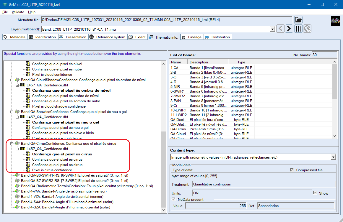
| LC08_L1TP_20210116_BQA-CirrusConfidence_RT.img | LC08_L1TP_20210116_BQA-ConfiancaCirrus_RT.img | LC08_L1TP_20210116_BQA-ConfianzaCirrus_RT.img |
| LC08_L1TP_20210116_BQA-B6-SWIR1-RS_RT.img | LC08_L1TP_20210116_BQA-B6-IRoc1-RS_RT.img | LC08_L1TP_20210116_BQA-B6-IRoc1-RS_RT.img |
| LC08_L1TP_20210116_BQA-B7-SWIR2-RS_RT.img | LC08_L1TP_20210116_BQA-B7-IRoc2-RS_RT.img | LC08_L1TP_20210116_BQA-B7-IRoc2-RS_RT.img |
| LC08_L1TP_20210116_BQA-Radiometric-TerrainOcclusion_RT.img | LC08_L1TP_20210116_BQA-OcultatPelTerreny_Radiometric_RT.img | LC08_L1TP_20210116_BQA-OcultadoPorElTerreno_Radiometrico_RT.img |
| LC08_L1TP_20210116_4-SAA_RT.img | LC08_L1TP_20210116_4-AIA_RT.img | LC08_L1TP_20210116_4-AAS_RT.img |
| LC08_L1TP_20210116_4-SZA_RT.img | LC08_L1TP_20210116_4-AIZ_RT.img | LC08_L1TP_20210116_4-AAV_RT.img |
| LC08_L1TP_20210116_4-VAA_RT.img | LC08_L1TP_20210116_4-AVA_RT.img | LC08_L1TP_20210116_4-ACS_RT.img |
| LC08_L1TP_20210116_4-VZA_RT.img | LC08_L1TP_20210116_4-AVZ_RT.img | LC08_L1TP_20210116_4-ACV_RT.img |
| LC08_L1TP_20210116_I.rel | LC08_L1TP_20210116_I.rel | LC08_L1TP_20210116_I.rel |
The horizontal reference system quality parameters corresponding to the following keys are stored in the metadata:
Thermal constants are added to the comments section.
GROUP = LEVEL1_THERMAL_CONSTANTS
Other parameters incorporated into comments are the following:
In old versions, in which there was sometimes indeterminacy in whether 0 acted as a NoData or not, uncertain situations could occur that could generate a small inaccuracy in the calculations of the transformation slope if the assumption was incorrect. These inaccuracies, if they existed, were small (clearly smaller than the inaccuracy in the absolute calibration offered by the sensor), but control has also been strengthened in this aspect.
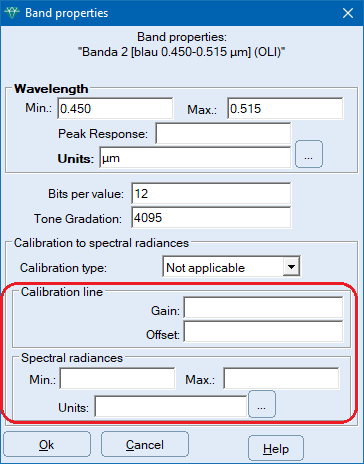
Below is an example with the MTL values and those added in the Radiometry section.
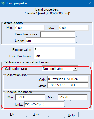
When importing Landsat data with processing level 2, the parameter groups that allow estimating the values of "terrain reflectances" or BOA reflectances are read, and the fields related to Radiance Calibration (or Spectral Radiances) in the radiometry section are left blank.
The estimated values of "ground reflectances" are calculated in percentages (%), and therefore differ from the units in DN (in fact, Qcal) provided by data with processing level 1. In each case these units are saved in the corresponding section of the metadata.
If this transformation in the processing level 2 data is not desired, but the .img data in the same byte or unsigned integer values (depending on the Landsat series sensor) within the TIF is wanted, it is possible to use TIFIMG in mode 2 (not 9) for specific bands, or GDALMM (which will import, however, less metadata), or once the TIF is open in MiraMon, select everything with the "Select all" button from the object selection box (right mouse button) and save the selection as .img. It should be noted, however, that this "manipulated" level 2 product is of little use without the conversion to % Reflectances for which it has been pre-calculated, and that is why the default TIFIMG import completes this pre-calculation.
An example is shown below with the values that are added in the Radiometry section for the case of Landsat data with level 2 processing.
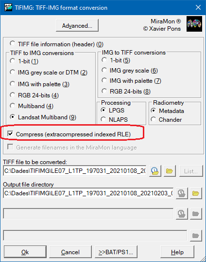
By default, "Compress extracompressed indexed RLE" is enabled. If this option is disabled, /NO_COMPRESS appears on the command line.

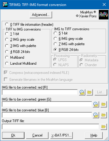  |
| TIFIMG dialog box |
TIFIMG 3 SCAN256 IMA256 IMA256.P25
TIFIMG 4 RGB BANDA_1 BANDA_2 BANDA_3
TIFIMG 4 MULTIBAN C:\RESULTADOS /PREFIX=BANDA_
TIFIMG 8 MOAG_7 MOAG_4 MOAG_3 D:\IMATGES\MOAG_FC 250000