-
 EvapoTr: Calculation of evapotranspiration
EvapoTr: Calculation of evapotranspiration| Presentation | Dialog box of the application |
| Syntax |
This program calculates evapotranspiration. The only option available is the calculation of potential evapotranspiration with the formula of Thornthwaite 1948.
The input raster can be in any IMG format supported by MiraMon (more information in MiraMon raster formats description). Temperatures are expected at °C, but the main units of English systems, such as inches ("inch") or degrees Fahrenheit, are also supported. Practically all multiples and submultiples are supported, which are converted to degrees Celsius (for example, d°C for decigrams Celsius typically stored in short integers, of 2 bytes).
The order in which the raster files are presented to the list files is used by the program to consider its sequence when forming the temporary series. In long lists it is advisable that the alphabetical ordering of the raster files provide this order in order to automate the creation of the ordered list and avoid errors, which would have obvious and fatal repercussions on the calculations. In this sense, it is suggested that the data of the raster file be part of the name and do it in format yearmonthday, or yearmonth (for example 20121231_temp for a file that contains the temperatures of December 31 of 2102, or 201212_temp if it contains the average temperatures of all December 2012). In this way, all the precipitation raster files from a directory can be sent to the list file correctly sorted by this command of the operating system, which sort by name (/on) and generates a simple list (/b):
dir *_temp.img /b /on > temp_list.txt
It should be notice that the files in the list that will appear in the temp_list.txt do not have a path, but the list and the files themselves are kept in the same directory, because the relative addresses are consistent, everything will work correctly.
The program calculates the latitude geodetically for the start and end of each row of the raster and is interpolated linearly between these values. This procedure is considered to be sufficiently accurate in the majority of cartographic projections and work areas. However, if a calculation of latitude in each cell is need, it is possible to write to suport@miramon.uab.cat.
For more information, consult the following reference:

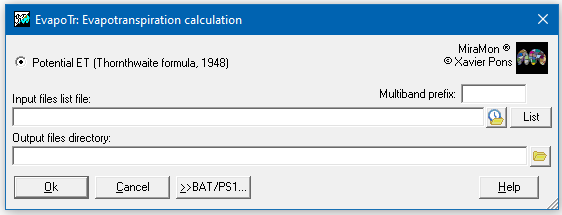 |
| EvapoTr dialog box |