-
 ErrorMDT: DTM error detection
Access this help text as a web page: ErrorMDT
Presentation and options
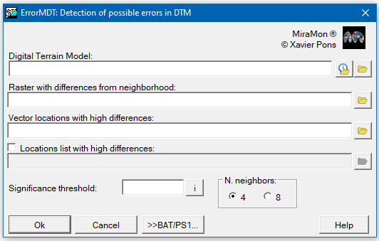
This application searches for locations in a Digital Terrain Model (MDT) that contain candidate values to be considered errors.
The program compares the value of each cell with the result of a local interpolation of its 4 or 8 neighbors. If this difference is high, higher than the Student's t indicated, it is marked as a suspected error location. The program generates a model with the differences in each cell and a non-structured point vector (VEC) with the locations with the possibility of being wrong. It is also possible to generate a report, in the form of a text file, which includes the list of these candidates. The verification algorithm simplifies the columns and extreme rows of the raster (column 0, row 0, last column and last row).
The algorithm is based on the method proposed in the article by Felicísimo Á M (1994) Parametric statistical method for error detection in digital elevation models ISPRS Journal of Photogrammetry and Remote Sensing, 49(4):29-33, with some improvements and additional sophistication.

Dialog box of the application
Syntax:
- ErrorMDT DTM DifferencesRaster ErrorsVector Student-t nNeighbors /DIFER_TXT
Parameters:
- DTM
(Digital terrain model -
Input parameter): Digital terrain model in raster format.
- DifferencesRaster
(Differences raster -
Output parameter): Raster in real IMG format with the differences between the MDT and the locally interpolated values.
- ErrorsVector
(Errors vector -
Output parameter): Vector points in VEC format with cell locations with high differences (above the value marked by Student's t).
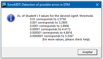
- Student-t
(Student t Value -
Input parameter): Student t value for the desired significance level (for example, for 0.01 is 2.5758, for 0.001 is 3.2905, for 0.0001 is 3.8906, for 0.00001 is 4.4172, for 0.000001 is 4.8933 y for 0.0000001 is 5.3631).
- nNeighbors
(Number of neighbors -
Input parameter): Number of neighbors used to perform interpolation. It is recommended to use 8 neighbors.
- 4: 4 neighbors
- 8: 8 neighbors
Modifiers:
/DIFER_TXT=
(List of differences)
List of differences higher than the indicated Student's t. (Output parameter)