-
 CreaRas: Create a new raster
Access this help text as a web page: CreaRas
Presentation
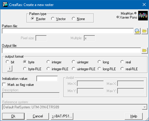
Creates a new raster from a pre-existing pattern file or with given characteristics that are entered manually.
This application allows to create a new raster (or a grid on a VEC file) from the coordinates and pixel size given in a file, that is used as a pattern. This file can be of type IMG, VEC, POL, ARC, PNT or NOD. It is also allowed to enter these data manually without using a pattern file.

Dialog box of the application
Syntax
Syntax:
- CreaRas PattFile OutputFile DataType FlagValue MarkFlagValue [CellSize] [Multiple] [/DESC_NODATA]
Parameters:
- PattFile
(Pattern file -
Input parameter): File that defines the geographical area of the map. It must be given with extension. If a pattern file is not provided, this parameter will be "NUL".
- OutputFile
(Output file -
Output parameter): New output file IMG raster (or a grid within a VEC).
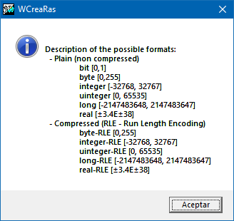
- DataType
(Data type -
Input parameter): Indicates the datatype of the new image. It can be any of the data types supported by MiraMon, for example "byte", "integer-RLE", etc.
- FlagValue
(Flag value -
Input parameter): Value that will be used to initialize the output raster file.
- MarkFlagValue
(Mark flag value -
Input parameter): Indicates whether the initialization value will be marked as flag value in the documentation file (1) or not (0).
- CellSize
(Pixel Size -
Input parameter): Size of the cell
- Multiple
(Multiple -
Input parameter): If PartternFile is a vector file, the program enlarges the geographical region so that the coordinates minX and minY of the new raster are multiple of Mult. In addition, in this case a minimum of one pixel will be included all around.
Modifiers:
/DESC_NODATA=
(No data description)
Optional parameter which allows to assign a descriptor to the flag value in the case that MarkFlagValue is activated. The default description is NODATA. (Input parameter)