 Universal Geospatial Metadata Manager. GeM+
GeM+ is a powerful and intuitive application for Windows that allows you to create, manage and edit metadata from very diverse sets of geographic information, whether we have access to the data or not. If we have data access (for example, to a TIFF that contains an image of interest) the GeM+, which is able to read the most common formats, will dynamically transfer to the metadata some information extracted from the data itself, thus avoiding transfer errors and keeping the information always consistent and automatically updated. This will help in increasing the productivity of your metadata editing.
Allows to document XML metadata of geographic information datasets available in any of the usual formats (such as a TIFF) or in a geospatial database (Oracle SDO). In case we don't have access to the data we can also type in all the information like in the old conventional editors.
Allows to work offline without an Internet connection.
GeM+ is distributed at no cost and doesn't require installation.
Watch the video: GeM+: A Tour through the Universal Geospatial Metadata Manager.
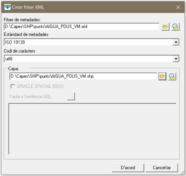
Create a new XML file |

Metadata editing |
Main functionalities
- Support to standards ISO 19115 of Geopgraphic Information ans ISO 19139 for export, import, and XML editing. It is also compliant with the INSPIRE regulations for implementing metadata.
- Application in Catalan, Spanish and English.
- Multilingual edition of metadata (in any language and up to four languages for each metadata file).
- Interface based on tabs organized in a conceptually coherent and intuitive way, beyond the simple concatenation of terms presented in some version of one of the different standards.
- Validation and consistency analysis system between metadata and/or the dataset.
- Direct association to a layer in any format (MiraMon's native or not) which saves time, avoids copy/paste errors and updates automatically. Examples of direct data extraction from the information in the layer itself (in the case of formats that store this information):
- columns and rows or the number of bits per cell in a raster,
- the number of entities and their typology (points, lines, etc.) in vector layers,
- the spatial reference system (projection, datum, etc.),
- the coordinates of the geographical envelope of the layer or its center in longitude-latitude coordinates,
- the vertical extension of 3D data,
- enumeration, typology, etc., of the fields of alphanumeric tables that accompany the data,
- file size,
- spectral regions of the bands of the remote sensing images, with automatic indication of the units.
- Direct opening, with a single click, to the cartographic information associated with the Universal Map Reader of the MiraMon for immediate visual validation (cartographic and in GIS analytical terms) of any aspect to be checked, consulted, etc., or simply to get an overview of the geographic information dataset.
- Direct opening, with a single click, of the alphanumeric information to explore the databases associated to the vector entities or raster cells.
- Extension of standards in case of special interest, such as the type of information that a raster layer can contain, the units of the vertical reference system, the spectral radiance converters of the remote sensing data, etc.
- Incorporation of keyword dictionaries (GEMET, IDEC and MiraMon's own thesaurus), thus facilitating much more extensive and numerous lists, organized hierarchically following the standardization of the Collective Catalog of the Universities of Catalonia ( Botany within Biology, etc.).
- In the case of the edition of metadata associated to layers MiraMon, allows the possibility to indicate appearances of symbolization and information on the quality of the data, as well as document automatically the complete lineage, with the detail of all the processes and parameters which have led to the creation of the set of geographic information whose metadata we are editing. In the case of metadata in XML format, the lineage can also be documented, but manually.
- No installation is required (runs from any folder, USB, etc.).
- It works offline , which makes it useful for working when you don't have an internet connection.