
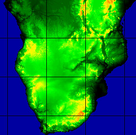
The whole image can be viewed only with Windows95 or WindowsNT. If you are using Windows 3.1x, or you have not enough memory, you must open one of the following three parts.
Whole DEM (0-35 S, 8-43 E) 30 062 124 bytes Res:30 arc second (RLE compressed)

 http://edcwww.cr.usgs.gov/landdaac/gtopo30/gtopo30.html ftp://edcftp.cr.usgs.gov/pub/data/gtopo30/global/README.TXT
 Internet: edc@eos.nasa.gov (24 hours)
PLEASE NOTE: This is an updated release of the Africa 30 arc second DEM.
Comments from users of this data set are welcome. Please contact Dean Gesch
(gesch@dg1.cr.usgs.gov) or Sue Jenson (jenson@dg1.cr.usgs.gov).
A digital elevation model (DEM) consists of a sampled array of elevations for
ground positions that are normally spaced at regular intervals. To meet the
needs of the geospatial data user community for regional and continental
scale elevation data, the staff at the U.S. Geological Survey's EROS Data
Center (EDC) are developing DEM's at a horizontal grid spacing of 30 arc
seconds (approximately 1 kilometer). These data are being made available to
the public via electronic distribution and hard media. As of July, 1996 data
are available for Africa, Antarctica, Asia, Europe, and North America. Data
sets for South America, Australia, New Zealand, the islands of southeast Asia,
and Greenland are under development and are scheduled for release before the
end of 1996.
Now (July 1997) the whole world are available
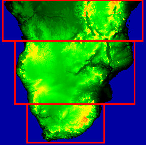
DEM file name   Latitude extent   Longitude extent

af30as_1.dem       40 N - 0         20 W - 20 E      (4800 rows x 4800 columns)
af30as_2.dem       40 N - 0         20 E - 60 E      (4800 rows x 4800 columns)
af30as_3.dem        0 - 35 S         5 E - 60 E      (4200 rows x 6600 columns)
In this CD you can view the last one only
The data are distributed as 16-bit simple binary raster image files (no header
or trailer bytes or records). The DEM files have been compressed using the
GNU 'gzip' utility, and they must be uncompressed before use. They can be
uncompressed with the gzip utilities, or if you do not have access to gzip
the FTP server can uncompress the files as you retrieve them. To do this,
simply leave off the ".gz" extension when retrieving a file (NOTE: This
option is not available through MOSAIC). For example, to retrieve the file
"af30as_1.dem.gz" without compression just use "get af30as_1.dem". Please
note that an uncompressed file is typically many times larger than the
compressed version and therefore will take much longer to transmit. If you
would like to obtain the gzip program, it is available via anonymous FTP at
the following sites:
ftp://prep.ai.mit.edu/pub/gnu
ftp://wuarchive.wustl.edu/systems/gnu
Each DEM is accompanied by four ancillary ASCII text files (header file, world
file, statistics file, and data descriptor record). The ancillary files are
named the same as the DEM with the file name extension indicating the file type.
The DEM and ancillary files are available through an Internet anonymous File Transfer Protocol (FTP) account at the EDC (at no cost).
To access this account:
1. FTP to 152.61.128.6 (edcftp.cr.usgs.gov)
2. Enter "anonymous" at the Name prompt.
3. Enter your email address at the Password prompt.
4. Change (cd) to the "pub/data/gtopo30/global" subdirectory.
6. Files are named with the following extensions :
*.dem.gz = compressed DEM file
*.hdr = header file
*.dmw = world file
*.stx = statistics file
*.ddr = data descriptor record.
7. Enter "binary" to set the transfer type.
8. Use get or mget to retrieve the desired files.
Alternatively, the data can be accessed through the World Wide Web at:
http://edcwww.cr.usgs.gov/landdaac/gtopo30/gtopo30.html
Orders for the data on hard media can be submitted to:
Customer Services
U.S. Geological Survey
EROS Data Center
Sioux Falls, SD 57198 USA
Tel: 605-594-6151 (7:30 am to 4:00 pm CT)
Fax: 605-594-6589 (24 hours)
Internet: custserv@edcserver1.cr.usgs.gov (24 hours)
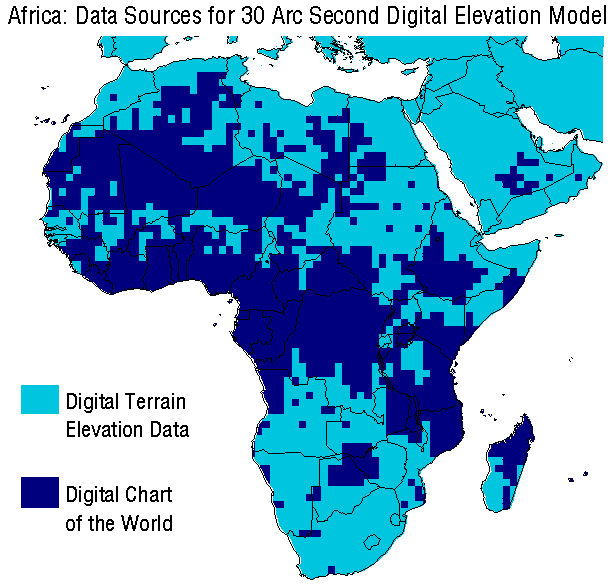
The Africa 30 arc second DEM was developed using commercially available geographic information system software, vector-to-raster gridding software, and utilities developed specifically for this project.
The DEM is based on data derived from two sources: Digital Chart of the World (DCW) and Digital Terrain Elevation Data (DTED). Approximately 56% of the Africa DEM is based on DTED, while the remaining 44% is based on DCW.
DCW is a vector cartographic data set based on the 1:1,000,000-scale Operational Navigation Chart (ONC) series, which is the largest scale base map source with global coverage (Danko, 1992). The DCW and the ONC series are products of the Defense Mapping Agency (DMA).
The topographic information of interest for generating DEM's is contained in several DCW hypsography layers. The primary contour interval on the source ONC's is 1000 feet (305 meters), and supplemental contours with an interval of 250 feet (76 meters) are found in areas below 1000 feet in elevation. Information from the DCW drainage layers was also used as input to the DEM generation process; this information included stream networks, lake shorelines, lake elevations, and ocean coastlines.
DTED, also a DMA product, is a raster topographic data base with a horizontal grid spacing of 3 arc seconds (approximately 90 meters). DTED are available for over 65% of the global land surface. Access to full resolution DTED for areas outside the United States is limited to agencies of the U.S. government, but permission has been granted by DMA to the EROS Data Center to use and distribute a generalized 30 arc second version.
The 3 arc second DTED were generalized to 30 arc seconds by selecting one elevation value to represent the area covered by 100 full resolution grid cells (a 10 by 10 matrix). The generalization approach emphasizes the topographic breaklines (ridges and stream channels) as found in the full resolution data. The goal is to retain as much of the significant topographic information as possible in the generalized DEM.
The topographic information from the DCW was converted into an elevation
grid through a vector-to-raster gridding approach. The hypsography,
drainage, and coastline data were input to the ANUDEM surface gridding
program developed at the Australian National University (Hutchinson, 1989).
ANUDEM, specifically designed for creating DEM's from digital contour, spot
height, and stream line data, employs an approach known as drainage
enforcement to produce raster elevation models that represent more closely
the actual terrain surface and contain fewer artifacts than those produced
with more general purpose surface interpolation routines. However, in order
to prepare and format the DCW for input to ANUDEM a significant amount
of preprocessing was required. This processing included editing and
updating the vector stream lines so that the direction of each was oriented
downstream, a requirement of ANUDEM. Further preprocessing involved
detection and correction of erroneous contour and point elevations (Larson,
1996).
Ocean coastlines were assigned an elevation of zero for input as contours.
Also, shorelines of lakes for which the DCW included elevations were
tagged and used as contour input. Additional point control was input into
the DCW gridding process in an effort to minimize the discrepancies along
the border between the DCW and DTED. Points derived from generalized
DTED within a 1-degree buffer surrounding the DCW areas were input to
ANUDEM so that the 30 arc second grids from the two sources would
match better in the overlap area.
The output from ANUDEM was an elevation model grid referenced in the same horizontal coordinate system as the generalized DTED. The output grid spacing of 30 arc seconds has been shown to be appropriate for the information content present in the DCW hypsography layers (Hutchinson, 1996; Shih and Chiu, 1996).
Prior to merging with the generalized DTED, several postprocessing steps were performed on the DCW grid. Lakes for which the DCW did not indicate an elevation were updated on the grid with the lowest grid cell elevation found along the shoreline. Also, an artifact of the surface interpolation process in areas just inland from the ocean coastline was detected and corrected. In these areas ANUDEM produced anomalous below sea level elevation values. Any grid cell that did not coincide with the DCW polygons that denote real below sea level areas was remapped to an elevation above sea level.
Merging of the generalized DTED and the DCW grid to produce the Africa
DEM was accomplished by mosaicing the two data sets. The generalized
DTED had the highest priority so that coverage of the source with the
greater topographic detail and accuracy was maximized. The DCW grid
filled in the areas of the African continent not covered by DTED. The
merging procedure included blending of the two data sources along the
irregular boundary to minimize the differences and smooth the transition.
The blending was performed in an overlap area of 1 degree (120 grid cells)
surrounding the DTED areas. The blending algorithm computes a weighted
average with the weights for each data source determined on a cell-by-cell
basis according to the cell's proximity to the edges of the overlap area
(Franke, 1982.) The final processing step performed on the mosaiced and
blended product involved "clipping out" the land (as defined by the DCW
coastline) and setting the ocean areas to a constant background value.
To characterize the accuracy of the areas of the Africa DEM derived from the DCW, the DCW grid was compared to 30 arc second DTED which had been aggregated by averaging. By aggregating, the comparison could be done at the 30 arc second cell size of the DCW grid. Eliminated from the comparison were those areas of the DCW grid for which supplemental DTED point control had been included in the gridding process. If the averaged DTED are thought of as the reference data set, the RMSE of the DCW grid is 95 meters. To get an idea of the overall absolute accuracy of the DCW grid, the relative error between the DCW and DTED can be combined with the known error of the DTED itself in a sum of squares. The root of that sum of squares (RSS) is 97 meters. Using the assumptions about the error distribution cited above, an RMSE of 97 meters can be expressed as + or - 162 meters linear error at 90% confidence. This number compares favorably with an expected vertical accuracy (linear error at 90%) of one-half of the primary contour interval of 1000 feet (305 meters) for the topographic maps on which the DCW is based.
The elevation data available here are a result of the global 30 arc-second
elevation data project being carried out by staff of the USGS' EROS Data Center
(EDC) in Sioux Falls, South Dakota and the co-located United Nations
Environment Program / Global Resource Information Database office (UNEP/GRID).
The broad goal of this project is the completion of global 1 km elevation data for
the land surface and the systematic extraction of derivative information to
assemble a global data base of topographic elevation, slope, aspect, hydrologic
flow paths, and watersheds. The primary collaborators and data contributors to
date are the USGS, NASA, UNEP/GRID, USAID, DMA, the Instituto Nacional de
Estadistica Geografica e Informatica (INEGI) of Mexico, and the Geographical
Survey Institute of Japan.
Danko, D.M., 1992. The digital chart of the world. GeoInfo Systems, 2:29- 36.
Defense Mapping Agency, 1986. Defense Mapping Agency product specifications for digital terrain elevation data (DTED) (2d ed.). Defense Mapping Agency Aerospace Center, St. Louis, Missouri, 26 p.
Franke, R., 1982. Smooth interpolation of scattered data by local thin plate splines. Computing & Mathematics with Applications, 8:273-281.
Hutchinson, M.F., 1989. A new procedure for gridding elevation and stream line data with automatic removal of spurious pits. Journal of Hydrology, 106:211-232.
Hutchinson, M.F., 1996. A locally adaptive approach to the interpolation
of digital elevation models. In: Proceedings, Third International
Conference/Workshop on Integrating GIS and Environmental Modeling,
Santa Fe, New Mexico, January 21-26, 1996. National Center for
Geographic Information and Analysis, Santa Barbara, California.
http://www.ncgia.ucsb.edu/conf/SANTA_FE_CD_ROM/main.html.
Larson, K.S., 1996. Error detection and correction of hypsography layers.
In: Proceedings, Sixteenth Annual ESRI User Conference, May 20-24, 1996.
Environmental Systems Research Institute, Inc., Redlands, California.
http://www.esri.com/ resources/userconf/proc96/WELCOME.HTM.
Shih, T.Y., and Chiu, Y.C., 1996. On the quality of DCW hypsographic data,
a study for Taiwan. In: Technical Papers, ASPRS/ACSM Annual Convention
and Exhibition, April 22-25, 1996, Baltimore, Maryland. American Society for
Photogrammetry and Remote Sensing, Bethesda, Maryland, Volume III, p.
248-257.
NOTE: Any use of trade, product, or firm names is for descriptive purposes only and does not imply endorsement by the U.S. Government.