World Data bank 2 (WDb-2)
View Map

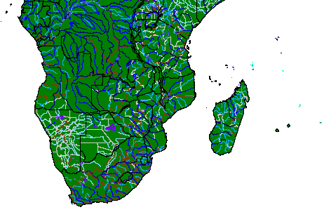

Data Set ID: GNV24
Original data set from:  UNEP/DEIA/GRID-Geneva
UNEP/GRID Documentation Summary for Data Set:
World Data bank 2 (WDb-2)
The original World Data bank (WDb) 2 product was digitized between 1972 and 1977 by the U. S.
Department of State's (DoS) Central Intelligence Agency (CIA), and released to the public in the
latter year. While the nominal scale of maps used for WDb-2 was one to 3 million (1:3,000,000),
parts of Europe, Central America, Southeast Asia and the Middle East were digitized at 1:1,000,000,
and the former northeastern USSR and Antarctica were input at 1:4,000,000. The GRID version of
WDb-2 is in an ARC/INFO 'EXPORT' format and contains a series of geographical
areas (Asia and Australia; Africa and Europe; North and South America), each of which includes a variety of
thematic coverages as follows:
- Coastlines, Islands and Lakes
- Rivers; major, minor and other
- National boundaries
- Internal boundaries (some areas only)
- Roads (some areas only)
- Railways (some areas only)
WDb-2 uses map scales from 1:1,000,000 to 1:4,000,000; nominally, a scale of 1:3,000,000 was
used to achieve the amount of detail desired. A total of 19 coverages ('EXPORT' data files) are
available, and all data have been kept in their original line topology; that is, no data have been
converted to polygons. Users who require boundary-related data in polygon format (e.g., country
polygons) are encouraged to obtain the generalized version of World Boundaries from GRID instead.
WDb-2 is recommended for users who need detailed boundary data at the continental, regional or
national level. Users who need less detailed boundary data at a global level only are again referred to
the more generalized version, which has sufficient detail for global-scale applications. Typically,
users of WDb-2 have a study area within a single continent or region. Although most large countries
exhibit reasonably detailed features (administrative boundaries, rivers, roads and railways) within
their boundaries, many smaller countries do not. Also, some of the WDb-2 coverages are inconsistent
at the national level, and many countries lack at least one of the thematic types of information (e.g.,
internal boundaries and/or roads) altogether.
WDb-2 consists of the following coverages:
| AMALLBDX | Americas (all); National Boundaries |
|
| AMALLBDI | Americas (all); Internal Boundaries |
|
| AMALLRRR | Americas (all); Railways |
|
| AMCENROA | Central America; Roads |
|
| AMNORCIL | North America; Coastlines, Islands and Lakes |
|
| AMNORRIV | North America; Rivers, major-minor-others |
|
| AMSUDCIL | South America; Coastlines, Islands and Lakes |
|
| AMSUDRIV | South America; Rivers, major-minor-others |
|
| ASIA_BDX | Asia; National Boundaries |
|
| ASIA_BDI | Asia; Internal Boundaries |
|
| ASIA_CIL | Asia; Coastlines, Islands and Lakes |
|
| ASIA_RIV | Asia; Rivers, major-minor-others |
|
| ASIA_ROA | Asia; Roads |
|
| ASIA_RRR | Asia; Railways |
|
| AFEURBDX | Africa and Europe; National Boundaries |
|
| AFEURBDI | Africa and Europe; Internal Boundaries |
|
| AFEURCIL | Africa and Europe; Coastlines, Islands and Lakes |
|
| AFEURRIV | Africa and Europe; Rivers, major-minor-others |
|
| AFEURRRR | Africa and Europe; Railways |
|
Code descriptions for the various attributes are as follows:
CIL - Coastlines, Islands and Lakes:ehp2.
| 01 | Coastlines, islands and lakes |
| 02 | Additional major islands and lakes |
| 03 | Intermediate islands and lakes |
| 04 | Minor islands and lakes |
| 06 | Intermittent major lakes |
| 07 | Intermittent minor lakes |
| 08 | Reefs |
| 09 | Salt pans, major |
| 10 | Salt pans, minor |
| 13 | Ice shelves, major |
| 14 | Ice shelves, minor |
| 15 | Glaciers |
RIV - Rivers; major, minor and others:ehp2.
| 01 | Permanent major rivers |
| 02 | Additional major rivers |
| 03 | Additional rivers |
| 04 | Minor rivers |
| 05 | Double-lined rivers |
| 06 | Intermittent rivers, major |
| 07 | Intermittent rivers, additional |
| 08 | Intermittent rivers, minor |
| 10 | Major canals |
| 11 | Canals of lesser importance |
| 12 | Canals, irrigation type |
BDX - National Boundaries or Limits of Sovereignty:ehp2.
| 01 | Demarcated or delimited |
| 02 | Indefinite or in dispute |
| 03 | Other line of separation or sovereignty on land |
BDI - Internal Boundaries:ehp2.
| 01 | First-order administration |
For Roads (ROA) and Railways (RRR), no special codes exist.
The reference to this data set is as follows:
"CIA, 1972. World Data bank 2. Central Intelligence Agency, Washington, D.C. USA."