-
 RegioPNT: Creating regions from punctual occurrences
Access this help text as a web page: RegioPnt
Presentation and options
This application generates a poligon vectorial layer from the thematic and spatial grouping of points. Typically it is used in the determination of regions of activity, influences, attends, etc of a certain species or variable, habitually booleana (0 or 1), from information received in punctual locations.
Regions from point occurrences by simple mode:
Only one region is generated and it has one percentage attribute, whole of 100 % or partially.influences, attends, etc of a certain species or variable, habitually booleana (0 or 1), from information received in punctual locations.
Regions from point occurrences by multiple mode:
Diferents regions with superposings are generated, from a low to a high percentage according to a constant increase.
The input information has to be in point (PNT) structured vectors.According to its database, it will be possible to realize a certainpre-selection that it will restrict of the whole of points, those that areincluded or not, for spatial criteria, of the corresponding resultantregion. This way, you are able to generate thematic groups determined by:for example area of a certain activity (rest, nutrition, etc) of a species,whenever in the input point layer database different attributes aregathered.
From the whole of points or of the pre-selection by attributes, it ispossible to establish a new points pre-selection points according to itsspatial distribution. These pre-selection will be defined by a percentage(when the sample of points is reduced, the percentage is not exact) of thewhole of points. The election of the points that generate the polygons canbe by different criteria:
- Distances from the center of the scope point distribution: the pointsare ordered from the distance to the central point of the distributionextreme coordinate and the N first points are selected according to thedefined percentage. This criteria is not recommended for non-homogeneousdistributions.
- Distances from the centroide of the point distribution: the points areordered from its distance to the centroide and the N first points areselected according to the defined percentage. In this case, as this ispoint distribution (this is not a continous distribution) the centroide iscalculated as the average of X coordinate and Y coordinate separately.This criteria, which would only coincide with the center of the scope fora uniform and regular distribution, habitually is most adapted fornon-homogeneous distributions.
- Distances from a point to de rest of the distribution: the distancesare calculated as the average of the distances from each point to the restof the distribution. These distances are ordered and the N first pointsare selected according to the defined percentage. It is a good criteriafor non-homogeneous distributions.
Once the distribution of points has been obtained from two possiblepre-selections (by attributes and by spatial distribution) the minimunconvex polygon is generated (convex hull) that includes inside it all thechosen points. This resulting polygon will keep as a not structured vectorVEC, or as a structured vector POL.
The selection by spatial distribution can be different results, dependingon the chosen percentage (from a minimum to a maximum percentage with aconstant increase). This possibility will give place to differentnon-structured polygons inside the same vectorial file, because the regionsof low percentage are included completely inside the regions of highpercentages. If the output selected format is POL (common topologicstructured format) it will give place to a particular case that admitssuperposing, the non-topologic polygon groups. If you want to re-docompletely the topologic structure to obtain non-grouped polygons, it willbe necessary to reconstruct them from its arches with the Ciclar application and to realize a selective cycling from thefield of the arch layer that has the percentage attribute.

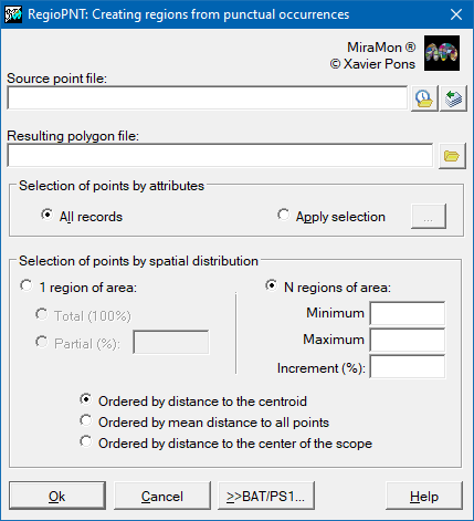
Dialog box of the application
Syntax
Syntax:
- RegioPNT 1 InputPNT OutputPOL LowPerc [/CRITERI_SEL]
- RegioPNT 2 InputPNT OutputPOL LowPerc HighPerc Increase [/CRITERI_SEL]
Options:
- 1:
Simple mode: only one region is generated and it has one percentage attribute, whole of 100 % or partially.
- 2:
Multiple mode: diferents regions with superposings are generated, from a low to a high percentage according to a constant increase.
Parameters:
- InputPNT
(Input Points -
Input parameter): Input file that contains the points in PNT format.
- OutputPOL
(Output Regions -
Output parameter): Output polygon file name that contains the regions generated from the chosen points. It can be in VEC or POL format.
- LowPerc
(Low Percent -
Input parameter): Low percentage for the multiple option, or percentage for the simple option. For a region with the whole points this parameter will take the value 100.
- HighPerc
(High Percent -
Input parameter): High percentage for the multiple option. If the entire increase from the low percentage is not multiple of Increase, the region of maximum percentage will be a minor value that if it was multiple.
- Increase
(Increase -
Input parameter): Constant percentage increase of points to generate different regions.
Modifiers:
/CRITERI_SEL= (Selection Criteria) For pre-selections from spatial distribution where it is necessary to restrict of the whole of points one certain percentage, the user can choose between the following criteria:- 1: Distances from the centroide of the point distribution. This is the automatic option.
- 2: Distances from a point to de rest of the distribution.
- 3: Distances from the center of the scope point distribution.
(Input parameter)
Syntax:
- RegioPNT 1 InputPNT OutputPOL LowPerc [/CRITERI_SEL] [AtribSelection]
- RegioPNT 2 InputPNT OutputPOL LowPerc HighPerc Increase [/CRITERI_SEL] [AtribSelection]
Options:
- 1:
Simple mode: only one region is generated and it has one percentage attribute, whole of 100 % or partially.
- 2:
Multiple mode: diferents regions with superposings are generated, from a low to a high percentage according to a constant increase.
Parameters:
- InputPNT
(Input Points -
Input parameter): Input file that contains the points in PNT format.
- OutputPOL
(Output Regions -
Output parameter): Output polygon file name that contains the regions generated from the chosen points. It can be in VEC or POL format.
- LowPerc
(Low Percent -
Input parameter): Low percentage for the multiple option, or percentage for the simple option. For a region with the whole points this parameter will take the value 100.
- HighPerc
(High Percent -
Input parameter): High percentage for the multiple option. If the entire increase from the low percentage is not multiple of Increase, the region of maximum percentage will be a minor value that if it was multiple.
- Increase
(Increase -
Input parameter): Constant percentage increase of points to generate different regions.
Modifiers:
/CRITERI_SEL= (Selection Criteria) For pre-selections from spatial distribution where it is necessary to restrict of the whole of points one certain percentage, the user can choose between the following criteria:- 1: Distances from the centroide of the point distribution. This is the automatic option.
- 2: Distances from a point to de rest of the distribution.
- 3: Distances from the center of the scope point distribution.
(Input parameter)
[AtribSelection]
This is the set of parameters that defines the selection. To know
more about the values of these parameters consult the document of
general syntax.