REMOTE SENSING OF FOREST FIRES
Remote sensing as a tool to map forest fires, to study the fire regime and their
effects on plant communities and the integration into a GIS
Raimon SALVADOR, Ricardo
DÍAZ- DELGADO, Jordi VALERIANO and Xavier PONS
A semiautomatic method to map forest fires during large periods by means of remote sensing imagery has been developed. This methodology has been applied to the period 1975-1993 and results have been given as a forest fire map series
and a fire history map of Catalonia (Northeast of Spain). These maps have been lately converted to vector layers and all results have been integrated into a GIS. The results have been contrasted to independent administration data and commission and omission errors have been evaluated. Fire frequencies and NDVI post-fire values have been used to retrieve valuable information on the
fire regime and to evaluate plant regeneration rates in Mediterranean plant communities. GIS tools are being used for further landscape analysis.
KEYWORDS:
Remote Sensing, MSS, NDVI, fire scars mapping, plant regeneration,
fire regimes.
INTRODUCTION
While giving a broad sight over wide areas, remote sensing images may provide comprehensive information of them, and since almost 40 years ago they have been used in many different types of studies included in various scientific
areas. From these applications it is worth pointing out the ones related with environmental sciences, such as those offered by meteorological, oceanic and earth observation satellites -the latter are frequently used in global scale studies-. Earth observation satellites are currently applied to detect an map burned areas by means of images of a vegetation index (NDVI) based on a specific
combination of red and near infrared bands, which specially reflects the amount of green vegetation.
Due to the lack of precise mapping of boundaries of fires occurring in many areas, remote sensing has been widely applied to obtain them. Once this information has been achieved, fire regimes and the regeneration of plant
communities have been analyzed in many regions of the world.
Time series of images are currently used to monitor -through NDVI values- the regeneration process followed by plant communities after forest fires. Regeneration ratios of different plant communities are compared and the effect
of other environmental factors on such a process is also studied. Finally, spatial patterns of fire sizes have been also analyzed.
STUDY AREA
The study region includes an area about 32000 km2 in the northeast of the Iberian Peninsula. Approximately 60% of the study area is covered by vegetation (mainly shrubland and forests) but a dense human settlement has
often lead to a considerable fragmentation of vegetation patches. Although there are some highly mountainous areas (1500-3000 m) with a cold winter climate, the majority of the study area has a Mediterranean climate, with a fair weather and a significant summer drought that frequently leads to forest fires [4].
SATELLITE IMAGES
Fragmentation of vegetation and high population restricts the average size of forest fires making not suitable to use NOAA-AVHRR for a detailed mapping. Among higher spatial resolution sensors, Landsat-MSS was selected as it provided
the longest time series of images. One hundred MSS full frames taken on board of Landsat satellites 1, 2, 4 and 5 were acquired from the 1975-1993 period.
Images had to be geometrically corrected and properly registered in order to be used in a time series analysis. The correction model of Palŕ and Pons
(1995), based on polynomials was applied to a group of control points over the whole set of images.
Standard gain and offset coefficients for each satellite and period were applied in order to transform digital numbers to radiance levels. Next, the radiometric correction model of Pons and Sole-Sugranyes (1994) was applied to obtain
reflectances, which may allow comparisons between images from different times of the year. A final normalization of the different bands by means of invariant training areas was required. Once all images were normalized, NDVI values were calculated from bands 2 and 4 of the MSS sensor.
METHODS
Fire Scar Detection
Subtraction of NDVI values between consecutive images was chosen as method for its simplicity and robustness. Crops, clouds and freshwaters [7] together with deciduous forests, yield also a sudden drop in NDVI values between subsequent images. In order to avoid confusions between these surfaces and burned areas
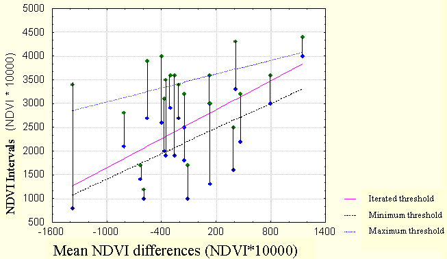
a set of masks were created and applied to the series of images. Once masks had been applied and consecutive date images subtracted, a threshold was determined by visually seeking the value that yielded best results for 21 previously located fires. Figure 1 shows the three different regression models that were used to build the 2 methods proposed. For further details on these methods
see Salvador et al. [8].
Data Integration and Fire Regime Analysis
Once applied the semiautomatic method, results were validated by using the administration inventories for the period 1983-93, provided by the DARP [3]. Omission and commission errors were given and possible causes of confusion
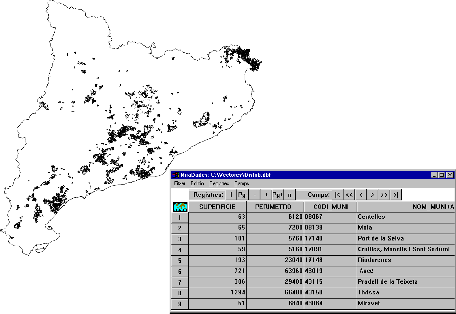
argued. Then, the fire-scars were integrated into a database GIS in a topologically structured vector format in order to consult several environmental and spatial parameters inherent to each fire (Figure 3). Such an information have been extracted to study the fire regime in Catalonia (extent, recurrence, intensity and seasonality of burns). Table 1 and 2 show some statistical information taken from field surveys of fire events occurred in the analyzed
period in Catalonia and also from those obtained from the methodology
described in Salvador et al.[2]
Spatial patterns of fire sizes have been also analysed and temporal patterns of burns are currently under study.
Plant Regeneration Monitoring
In order to examine the variability of the vegetation responses to fire, the results were also employed to locate fire scars and to select from them several burned areas to monitor their regeneration processes . This variability is
evaluated from rates of recovery after fire in different Mediterranean plant communities located in several areas of Catalonia. In this part of the study we attempted to fit regression models on the dynamics of the regeneration processes -monitored by the NDVI response- and to analyze the influence of several environmental parameters on such dynamics [1].
| Number of fires |
Burnt surface (km2) |
Averaged Number of fires/year |
Averaged burnt surface (km2)/year |
| 699 |
2248 |
36.8 |
118.3 |
Table 1: Fire statistics of Catalonia during the 1975-93 period obtained from administration inventories. Sources : Departament d'Agricultura, Ramaderia i Pesca (DARP) and Instituto para la Conservación de la Naturaleza (ICONA).
| Frequency of fires >30 ha in 19 years |
Burnt surface (ha) |
% of forested surface (ha) |
| Once |
111008.88 |
5,7 |
| Twice |
14506.56 |
0.74 |
| Three times |
1532.52 |
0.078 |
| Four times |
395.64 |
0.02 |
| Five times |
66.96 |
0.0034 |
Table 2: Frequency values and surfaces affected by fire recurrence, extracted from the map series of fire history of Catalonia (period 1975-93). Source : Salvador et al., 1997.
RESULTS
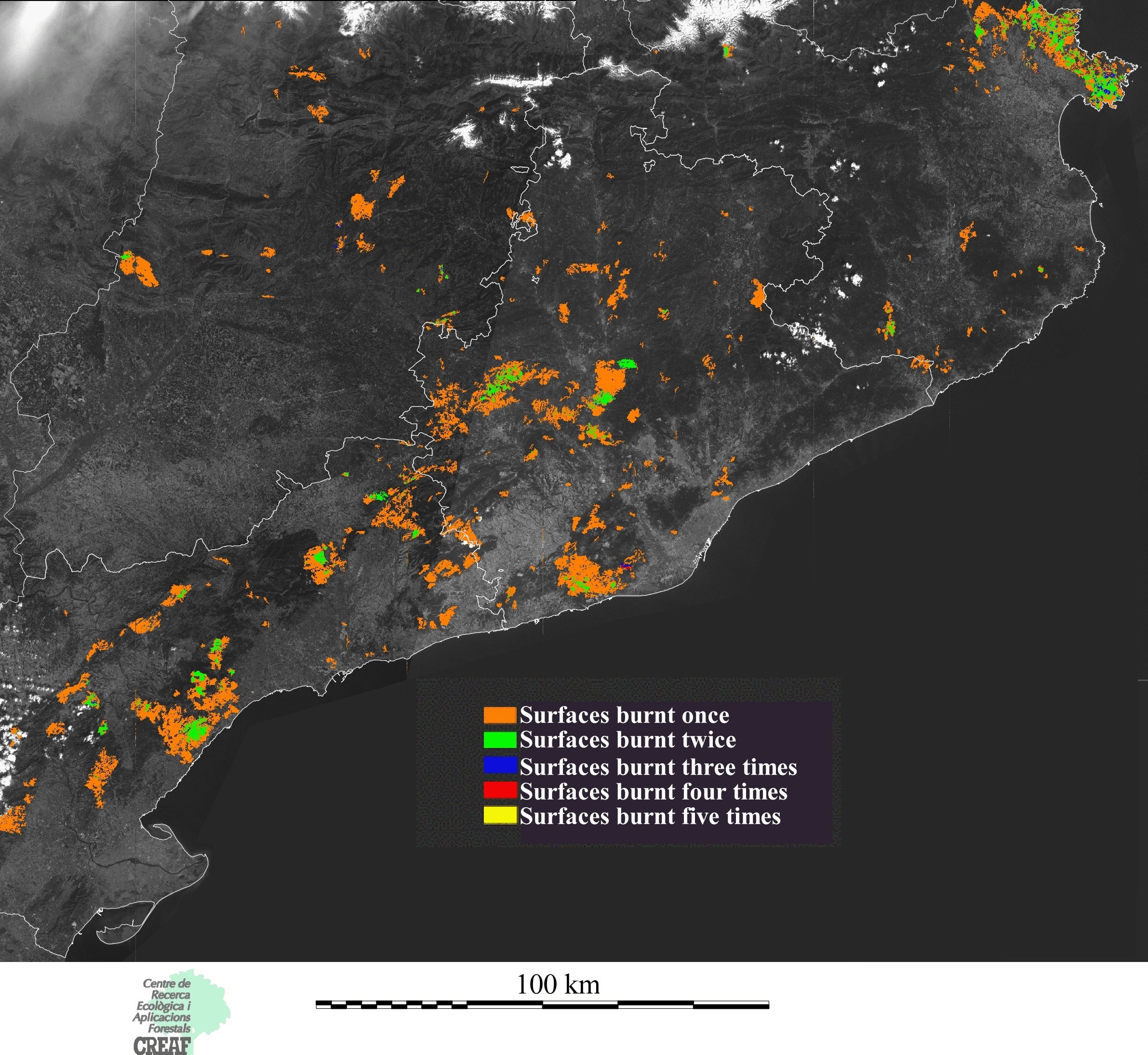
Figure 5 displays the fire-history map of Catalonia and the frequencies of fire obtained by using one of the employed methods (the more restrictive) during the
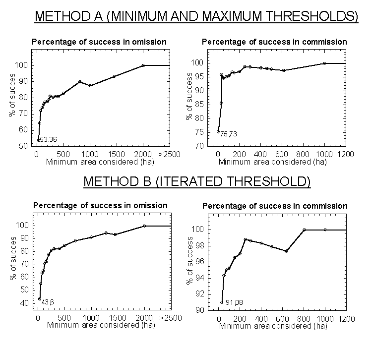
period 1975-1993. This method discriminated 53.36 % of fires greater or equal than 30 ha (175 fires), notably more than the 43.60 % of fires detected by the other applied method (143 fires) [8]. The degree of detection improved as the size of fires increased, reaching 78 % for fires of 200 ha.
In addition to the error arising from real fires not being detected, the accuracy should also be quantified in terms of the error arising from mapped areas which were not really burned patches (commission error). Figure 2 shows
for both methods the proportions of discriminated areas that corresponded
to real fires. In this case, unlike the omission error, considering all the fires greater or equal than 30 ha, the accuracy of method A (91.08 %) was quite superior to that of method B (75.73 %).
Some preliminary results about characterising fire spatial patterns showed that the 80% of the total area burned in Catalonia comes from small fires.
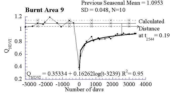
Monitoring of plant regeneration after fire in different burned areas yielded a good technical approach to compare previous and post-fire NDVI values by using
the NDVI quotient between burned areas and control sites (see figure 4). For further details on results see Díaz-Delgado et al., 1998.
CONCLUSIONS
Satellite images have a considerable value for mapping burned areas. Knowledge about these areas can aid understanding of the structure and dynamics of the vegetated landscape. Furthermore, there is global interest in monitoring fire regimes. Despite technical problems due to its age, images from the MSS sensor are particularly useful for the task of fire
mapping.
The linear models developed in this analysis, even though based on a simple method such as NDVI subtraction, have produced quite acceptable results. The level of accuracy clearly increased with the area burnt in fires, taking
into account all the burnt areas equal or greater than 30 ha.
A range of factors must be acknowledged as possible causes of the observed imprecision in the results of this work. Many of them can be minimized in future analysis. Increasing temporal resolution can considerably reduce the effect
of phenology and the time lag between fire and image recording. The vegetation density prior to fire can be considered in future works, by means of the use of mean NDVI values for the area analyzed. Other factors, however, can not be controlled, for example the different fire intensities, soil response in sparse shrub-covered zones and clearing activities.
Concerning to the plant regeneration monitoring we want to point out the interest of employing the previous interval of variation in similar approaches (see figure 4): this range may be used as a reference to determine the maximum
expected level of plant recovery to be attained in the first recovery
process.
FIGURES
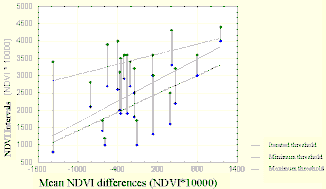
Figure. 1: Intervals of NDVI variations through time and the differences between consecutive images for the 21 real fires employed. Graphic also shows the regression models adjusted to the minimum and maximum values that were employed to discriminate the fire-scars according to the 2 methods.
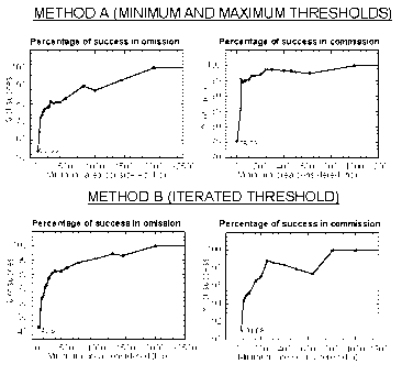
Figure. 2: Graphics show the percentages of omission and commission errors for both methods and their variation according to the increasing size (minimum area considered).
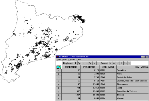
Figure 3: The map shows the Catalonia region and all the fire-scars detected with method B. Different fire parameters can be consulted by means of Miradades and Miramon software as an integrated GIS database.
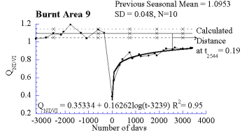
Figure 4: Evolution of NDVI quotient (QNDVI) between burnt area and control area before and after the Maresme fire in 1983. Chart also show
the adjusted logarithmic model and the distance to pre-fire NDVI values in time t=2544 days in order to compare all the burned zones.
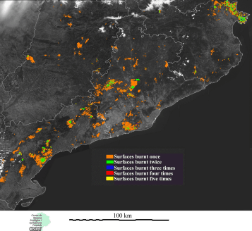
Figure 5: Map of burnt forested areas and frequency of wildfires in Catalonia during the period 1975-1993. Method of the maximum and minimum thresholds.
ACKNOWLEDGMENTS
We would thank to the Departament d'Agricultura (DARP,
Generalitat de Catalunya) for the statistical data supplied and
to Institut Cartogrŕfic de Catalunya (ICC) for the collaboration
in the geometric correction process. This project was funded by
a grant provided by the Spanish Comisión Interdepartamental
de Ciencia y Tecnología (CICYT AMB94-0881), by the LUCIFER
EC project, by a fellowship from the Generalitat de Catalunya
to Raimon Salvador and by a fellowship from the Ministerio de
Educación y Cultura to Ricardo Díaz-Delgado.
REFERENCES
- Díaz-Delgado, R.,Salvador, R. and Pons, X. Monitoring of Plant Communities Regeneration after Fire by Remote Sensing. Submitted. International Journal of Wildland Fire, 1998.
- Salvador R., Pons X.,Valeriano, J., Romeu J. and Palŕ V. Un método de análisis de los incendios ocurridos en Cataluńa durante el periodo 1975-1993 mediante imágenes de satélite. Proceedings of the Spanish Remote Sensing Association Congress. C. Hernández y J. E. Arias (eds.). Santiago de Compostela, 1997.
- Díaz-Delgado, R., Salvador, R., Valeriano, J. and Pons, X. Resultados y valoración estadística de un método automático de detección de superficies forestales quemadas en Cataluńa (periodo 1975-1993). Proceedings of the Spanish Remote Sensing Association Congress. C. Hernández y J. Arias (eds.). Santiago de Compostela, 1997.
- Terradas, J. and Pińol, P. Els gran incendis: condiciones meteorolňgiques i de vegetació per al seu desenvolupament.
In Ecologia del Foc ed. by J. Terradas. 1996
- Palŕ, V. and Pons, X. Incorporation of relief into geometric correction based on polynomials. Photogrammetric Engineering and Remote Sensing 7: 935-944, 1995.
- Pons X. and Solé-Sugrańes. L. A simple radiometric
correction model to improve automatic mapping of vegetation from multispectral satellite data. Remote Sensing of Environment, 48. 191-204, 1994.
- Salvador, R. and Pons, X. Analysis of the discrimination of burnt sites temporal evolution in a Mediterranean area. EARSeL Advances in Remote Sensing 4: 159-169, 1996.
- Salvador, R., Valeriano, J., Pons, X. and Díaz-Delgado, R. Application of a Semiautomatic Method to Detect Burned Areas using a Landsat MSS time series. International Journal of Remote Sensing. Submitted. 1998.
Raimon SALVADOR
r.salvador@creaf..uab.cat
Raymond Salvador received his BS degree in Biology in 1991 and a MS degree in Botany in 1994, and a PhD degree in Remote Sensing in 1992, all from the Autonomous University of Barcelona. His main work has been done in radiometric
and geometric corrections of satellite imagery, in cartography of ecological and forest parameters from airborne and satellite sensors and in studies of the spectral response of Mediterranean vegetation.
Centre for Ecological Research and Applied Forestry, CREAF.
Autonomous University of Barcelona (UAB)
08193 Bellaterra, Barcelona
Spain
Tel: +34.93 581 18 77
Fax: +34.93 581 13 12
URL: https://www.creaf.uab.cat
Ricardo DIAZ-DELGADO
r.diaz@creaf..uab.cat
Ricardo Díaz-Delgado received his BS degree in Biology in 1994 at UAM and a MS degree in Mediterranean Ecosystems in 1996 and a MS degree in Remote Sensing Applications at the Institute for Space Studies of Catalonia in 1997.. He is currently working in his PhD degree in Application of Remote Sensing
to Fire Ecology at the Autonomous University of Barcelona. His main work has been done in fire ecology concerning aspects of plant regeneration, community succession, cartography of fires from satellite sensors and in studies of the spectral response of Mediterranean vegetation.
Centre for Ecological Research and Applied Forestry, CREAF.
Autonomous University of Barcelona (UAB)
08193 Bellaterra, Barcelona
Spain
Tel: +34.93 581 18 77
Fax: +34.93 581 13 12
URL: https://www.creaf.uab.cat
Jordi VALERIANO
Ibec7@uab.cat
Jordi Valeriano received his BS degree in Physics in 1994 at the University of Barcelona and a MS degree in Satellite Applications and Remote Sensing at the Institute for Space Studies of Catalonia in 1995. He has mainly worked in
the definition of specifications for a space forest observing system, in Remote Sensing of forest fires and programming of image processing and visual tools for photogrammetry and GIS.
He is professor and cordinates the MS in Remote Sensing Applications that is held at the Institute for Space Studies of Catalonia every two years. He works since 1995 at the Centre for Ecological Research and Applied Forestry.
Centre for Ecological Research and Applied Forestry, CREAF.
Autonomous University of Barcelona (UAB)
08193 Bellaterra, Barcelona
Spain
Tel: +34.93 581 17 71
Fax: +34.93 581 13 12
URL: https://www.creaf.uab.cat
Xavier PONS
x.pons@uab.cat
Xavier Pons received his BS degree in Biology in 1988, a MS degree in Botany in 1990, a MS degree in Geography in 1995, and a PhD degree in Remote Sensing and GIS in 1992, all from the Autonomous University of Barcelona. His
main work has been done in radiometric and geometric corrections of satellite imagery, in cartography of ecological and forest parameters from airborne sensors, in studies of the spectral response of Mediterranean vegetation and in GIS development, both in terms of data structure and organization and in terms of software writing.
He has recently worked in descriptive climatology models, in modelling forest fire hazards and in analysis of landscape changes from long series of satellite images.
He is professor at the Department of Geography of the Autonomous University of Barcelona and coordinates research activities in GIS and Remote Sensing at the Centre for Ecological Research and Applied Forestry.
Department of Geography and
Centre for Ecological Research and Applied Forestry, CREAF.
Autonomous University of Barcelona (UAB)
08193 Bellaterra, Barcelona
Spain
Tel: +34.93 581 13 12
Fax: +34.93 581 13 12
URL: https://www.creaf.uab.cat