
Since 1988 the Centre for Ecological Research and Applied Forestry (CREAF) has been carrying out SIBosC, the Information System of Forests of Catalonia (NE Spain), by assignment of the Catalan government. SIBosC combines the forest data generated from the sampling plots of the Ecological and Forest Inventory of Catalonia (IEFC) and from the Land Cover Map of Catalonia (LCMC) together with other layers of forest cartographic information like Fuel and Flammability Models (FFMM). In order to allow the user's access to all this information, software utilities have been developed: statistics of forest database, MiraBosc, and a geographic information system, MiraMon.
KEYWORDS: Forest inventories, Land cover mapping, Fuel models mapping, Flammability models mapping, Catalonia, Forest Database
The knowledge of the natural
environment status needs an accurate and geographically extended
information. This can be derived from the basic land covers (geographic
location, surfaces) and from field sampling of those variables
related to vegetation (demography, specific composition, biomass,
yield, strata coverage, etc.). Both geographic information and
databases associated must be easily and periodically updated.
In order to accomplish this task
the CREAF has been developing since 1988 the SIBosC, wich comprises
the Ecological and Forest Inventory of Catalonia (IEFC) and the
Land Cover Map of Catalonia (LCMC) as the main projects. The geographic
boundary is that of Catalonia (NE of Spain) with a total extension
of 31874 km2. The main goal is to provide a useful
tool for the government of Catalonia to draw the main guidelines
for the future management of Catalan forests.
Mediterranean ecosystems are
affected by disturbances such as forest fires. In this context
the database of SIBosC on vegetation structure provides useful information
to generate new layers on fire risk (flammability models)
and on fire propagation (fuel models).
The data that come from the Forest
Inventories give only punctual information (only around the sampling
plot) which should be extrapolated to the whole territory. Multispectral
satellite imagery obtained from remote sensors (CASI, TM) can
serve to relate, by means of a model, some variables measured
in IEFC's sampling plots with its radiometric values. This model
can be used to extrapolate each one of the continuous variables
and to produce a spatial layer.
The conjunction and interrelation
of several factors such as a detailed scale land cover map, a
complete georeferenced forest database, fire prevention model
maps and an estimate of ecological variables over broad territories
by means of remote sensing make SIBosC a remarkable example of
a GIS applied to forest management.
Next, each one of the SIBosC
components will be described (its characteristics, materials,
methodology used and the actual project status).
Today, there is no land cover
and land use cartography of Catalonia at a detailed scale and
which is relatively recent. Nevertheless, a product with these
characteristics would be very useful for land management and planning.
With this cartography it should be possible to know the area occupied
by each cover type, to quickly update it, and to be capable of
using it in a cartographic representation based on many information
layers by means of a geographic information system.
The LCMC is a digital product
that includes the basic land covers of forest interest, that is
to say, delimited forests differentiated in two categories: more
than 20% coverage and between 5% and 20% coverage, shrubs and
meadows. Also, other interest areas are represented: burnt areas,
rock outcrops, water bodies (lakes, rivers and dams), crops, urban
zones, bare areas, etc.
Area delimitation is made by
photointerpretation and on-screen digitizing in a personal computer
using the in-house developed MiraMon software. This allows automatic
computation and using elements of other preexisting digital cartography
as a direct support to the process. The base materials for photointerpretation
are the 1:25000 orthophotomaps in natural color produced by the
Cartographic Institute of Catalonia. This product is used in digital
format (pixel size: 2 m). The working scale is about 1:3000, which
allows good image visualization. The error made in delimiting
boundaries is below 5 meters. Minimum digitized area is 500 m2
for the whole 31874 km2. Every digitized area receives
an attribute representing its cover type. (Figure 1).
Out of this process, a base of polygons is obtained. This base is divided
in sheets, which match the 1:25000 cartographic series. This format is also
converted to raster format, with a planimetric pixel size of 2 m.
With the LCMC, we can obtain
the forest area at the level of county, town, etc. and the corresponding
maps. This cartography can be used to plan field sampling (i.e.,
forest inventories), infrastructures (irrigable lands, communication
ways, power lines distribution), environmental impact assessments,
corridors between natural areas, etc.
At present day the LCMC contains
almost half of Catalonia. It is used in many institutions of the
public administration, not only in its original format, but also
as a high planimetric precision cover over which other applications
or studies can be made, for instance enriching their legends,
updates, etc.
The IEFC is an extensive database
from the forests of Catalonia. It includes the classic information
of forest inventories and some data related to functional aspects
of forest ecosystems. This complementary information allows to
know how the forest responds to some disturbances, linking forest
data to remote sensing images, etc.
The result is an extensive database
from about 10600 field-sampling plots [4]. The LCMC is used as
the base to place plots randomly at a ratio of one per km2
of forest area. This database includes over 34 000 records and
200 fields each one. The information is given for each species
and for all of them together. This kind of extensive study is,
first of all, a data bank that describes the present status of
Catalan forests, but their current conditions can also be checked
and their future evolution foreseen.
As any classic forest inventory,
the IEFC measures, on every sampling plot and for every tree species,
all the parameters needed in the calculation of structure patterns,
demography, wood volume and production, etc. With respect to other
parameters, this inventory also gathers information about functional
aspects related to nutritional status and light and water patterns.
The way these variables act in synthesis and support of the plant
components, especially on leaves, is decisive.
The response of forests to any
disturbance (fires, drought, human accessibility, thinning and
coppice, global change, etc.) depends on their previous status
(canopy development, diameter distribution, tree age, vigor, etc.),
on their accessibility to resources, on climatology and on relief.
Taking into account all these
features, those parameters and patterns that allow the calculation
of leaf area index (LAI), tree coverage, litterfall, sapwood basal
area, wood biomass, bark, branches and leaves and their nutrients'
content, annual tree growth, tree age, etc, has been measured.
The sampling area is circular,
usually with a radius of 10 m. For each tree with a DBH (diameter
at breast height - 1.30 m) above 5 cm its species is annotated
and its DBH measured. For each representative tree (one or more)
of each diametric class, height, canopy diameter, bark width,
stem shape, number of branches according to their size, etc are
measured.
Other remarkable kinds of information
gathered are understory transects, phytosanitary state, litter
samples, the analysis of nutrient content (C, N, P, Mg, S, Ca,
K) in leaves, branches, wood and bark. Diameter and weight of
branches related to weight of leaves are measured and also the
annual radial growth of wood
The study of fire risk and propagation
can be enhanced by the existence of maps of vegetation composition
and structure. Although the evident interest of Fuel and Flammability
Model Layers, it is not easy to produce them. These maps are especially
interesting in Mediterranean areas frequently affected by fires.
The ecological parameters from
IEFC sampling allow the cartographic representation of the flammability
and fuel models.
The fuel models allow to determine
through which vegetation stratum fire spread occurs [8]. Fuels
have been classified into four groups (grasses, brush, timber
and slash), according to the structure of the vegetation (horizontal
and vertical structure, height, ratio of alive/dead fuel load,
etc.) making a total of 13 fuel models [1].
The flammability of a sample
can be determined with an epiradiometer (constant heat source)
measuring the time spent until a flame appears and the percentage
of positive assays. Taking into account these two measures, species
can be classified into 4 categories from lowly to highly flammable.
The flammability [5] of the different species and their relative
land coverage define the flammability models. Both aspects derive
on 10 models, increasing the risk of fire ignition according to
their value. In such a way, lower models represent vegetation
formations with low coverage and low flammable species and higher
values define high coverage and high flammable species.
From the existing information
of the structure of the vegetation provided by the IEFC, fuel
and flammability models are assigned to each field plot. On the
other hand, the different categories in the map legend of the
Catalan Forest Map are reclassified according to the main types
of forests that are relevant for fuel and flammability models.
Both kinds of information are joined and interpolated by territorial
extension [6] to connect field plots information to vegetation
patches. Model assignment is avoided on areas with very different
vegetation types (so the models too). This technique provides
more realistic results because it avoids filling areas with non-possible
values coming from a nearby plot. For example, riparian vegetation
often needs to be considered from relatively far plots, because
the nearest plots can be of a very different nature from the flammability
point of view.
Nowadays, Fuel and Flammability
Models Maps, at a scale 1:100000 cover about 40% of the area of
Catalonia (56% of forest area, figure 2).
The flammability models map allows
to divide the territory in different zones according to their
probability of fire ignition. This map and the fuel models map
allow the distribution of fire watchmen and, once the fire has
begun, are useful tools in the fire extinction work.
A complex and extensive database
as the SIBosC needs some tools that allow to organize information,
represent it and query it from different points of view. In order
to make this task easier for the user some software utilities
have been developed by CREAF: MiraBosc, statistics of forest database
and the MiraMon GIS (Figure 3).
The MiraBosc program allows the
user to join in a file the results of different sampling plots
from the IEFC that agree with certain conditions (being in the
same geographic area, having the same relief conditions, etc.).
The geographic area can be obtained either from an existing file
(state or district limits, protected areas, etc.) or by creating
a new file with the digitizing module of MiraMon. The MiraBosc
program allows different types of query involving one or more
species within a determinate percentage of presence. The queries
result in statistical data (minimum, maximum and mean values,
standard error and number of plots included in the query). The
output information is: demography, canopy structure, understorey
structure, volume, production and biomass of each aerial fraction,
age and growth rate, nutrients concentration and mineralomass,
etc. These results can be illustrated graphically as histograms
and can also be printed.
In addition to photointerpretation
and on-screen digitizing, MiraMon allows to query the geographic
data associated to any object, such as point type (a plot from
the IEFC), polygon type (a forested area, a protected area, a
burnt area) or line type (a contour line or a power line). According
to this, the data corresponding to each IEFC plot can be analyzed
simply by clicking with the mouse. The other possibility that
the program provides is the query by attribute. Given some determinate
conditions from specific database fields the program selects the
graphic objects that agree with those conditions and shows their
geographic location on the screen.
The query by attribute is especially
useful to select IEFC's sampling plots according to species' structural
or demographic characteristics, such as tree coverage basal area,
density (information by vegetation strata), etc. Statistics information
resulting from the selected plots can be consulted with MiraBosc
software (option 'import to MiraBosc' see figure 3).
The reverse process is also available:
IEFC's plots selected with MiraBosc can be represented across
the territory by means of MiraMon software; exporting the information
related to their geographic location (option 'export to MiraMon'
see figure 3).
The LCMC allows to know the forest
area at the level of county, town, etc., and to obtain the corresponding
maps. As already said, this cartography is used to plan field
sampling of IEFC. It is also used for environmental impact assessments
and to determine corridors between natural areas.
On the other hand, this extensive
information has allowed to test the usefulness of both satellite
and airborne remote sensors such as TM, MSS or CASI [2, 9] to
estimate forest variables.
At present, the information derived
from SIBosC is being implemented for the management of all Natural
Parks of Catalonia. It also has been distributed to the government
delegation over the territory.
The information from the IEFC
has allowed to give some general trends on woody species biodiversity
for different forest types and the relationship of these species
with shrub coverage and altitude [10].
The cartography derived from
LCMC has allowed to test forest landscape fragmentation, to study
the number of forest patches, its relative ratio, its dimension,
and the influence of fragmentation on biodiversity [3].

Figure 2. Fragment of Catalan Fuel Models Map (1:500000). Most of the fuel models in Catalan littoral are shrub group. This kind of model causes a
larger spread of fire and flame length which makes extinction tasks harder.
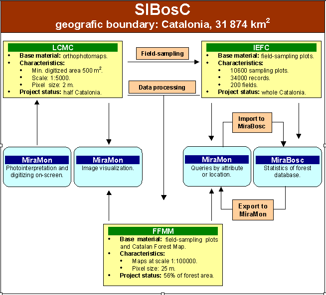
Figure 3. Relationship between the different components of SIBosC and
associated software programs: MiraMon and MiraBosc. LCMC means Land Cover
Map of Catalonia, IEFC is the Ecological Forest Inventory of Catalonia and
FFMM means Fuel and Flammability Models Mapping.
Carles Gracia received his BS degree in Biology in 1976 and his PhD degree in ecophysiology of water and chlorophyll in Mediterranean plants in 1992, all from the University of Barcelona.
His main work has been done in Mediterranean terrestrial ecosystems, mainly evergreen oak forests, their ecophysiology and their responses to drought and fire.
He has recently worked in Mediterranean forests computer modeling, in the analysis of the responses of evergreen oak forests to thinning (water use efficiency studies) and the effect of SO2 and O3 on Aleppo pine physiology.
He is a researcher of the Centre for Ecological Research and Applied Forestry and the Ecological and Forest Inventory of Catalonia manager.
At present he is one of the co-ordinators of an European project about carbon balance mapping (Long term effects of CO2 - increase and Climate Change on European Forests -LTEEF II)
He is professor at the Department of Ecology of the University of Barcelona and co-ordinates research activities at the Centre for Ecological Research and Applied Forestry.
Department of Ecology
University of Barcelona (UAB)
Avda. Diagonal, 645
08028, Barcelona
Spain
Tel: +34 93 402 15 11
Fax: +34 93 411 14 38
URL: https://www.creaf.uab.cat
Joan Josep Ibŕńez received his BS degree in Biology in 1984, from the University of Barcelona.
His main work has been done in forest ecology.
He has recently worked in fuel models and flammability models mapping and forests regeneration after wildfires.
He is researcher at the Centre for Ecological Research and Applied Forestry of the Autonomous University
of Barcelona from 1988 and coordinates realization of Ecological and Forest Inventory of Catalonia, 1988-98.
Centre for Ecological Research and Applied Forestry, CREAF.
Autonomous University of Barcelona (UAB)
08193 Bellaterra, Barcelona
Spain
Tel: +34 93 581 19 20
Fax: +34 93 581 13 12
URL: https://www.creaf.uab.cat
Jordi Vayreda received his BS degree in Biology in 1990, from the University of Barcelona. He is researcher at the Centre for Ecological Research and Applied Forestry of the Autonomous University of Barcelona from 1991.
He has been working in processing de forest database of Ecological and Forest Inventory of Catalonia also he has been responsible for development and verification of software related with this inventory.
He has been developing the methodology to make fuel and flammability models mapping. He has recently responsible of MiraBosc development in terms of software writing for management Ecological and Forest Inventory of Catalonia database
Centre for Ecological Research and Applied Forestry, CREAF.
Autonomous University of Barcelona (UAB)
08193 Bellaterra, Barcelona
Spain
Tel: +34 93 581 13 12
Fax: +34 93 581 13 12
URL: https://www.creaf.uab.cat
Xavier Pons received his BS degree in Biology in 1988, a MS degree in Botany in 1990, a MS degree in Geography in 1995, and a PhD degree in Remote Sensing and GIS in 1992, all from the Autonomous University of Barcelona. His main work has been done in radiometric and geometric corrections of satellite imagery, in cartography of ecological and forest parameters from airborne sensors, in studies of the spectral response of Mediterranean vegetation and in GIS development, both in terms of data structure and organisation and in terms of software writing.
He has recently worked in descriptive climatology models, in modelling forest fire hazards and in analysis of landscape changes from long series of satellite images.
He is professor at the Department of Geography of the Autonomous University of Barcelona and coordinates research activities in GIS and Remote Sensing at the Centre for Ecological Research and Applied Forestry.
Department of Geography and
Centre for Ecological Research and Applied Forestry, CREAF.
Autonomous University of Barcelona (UAB)
08193 Bellaterra, Barcelona
Spain
Tel: +34 93 581 13 12
Fax: +34 93 581 13 12
URL: https://www.creaf.uab.cat
José Ángel Burriel received his BS degree in Biology in 1988, from the University of Barcelona. His main work has been done in cartography of vegetation, and in studies of the response of Mediterranean forest to climate and competition.
He has recently worked in analysis of forest fragmentation.
He is researcher at the Centre for Ecological Research and Applied Forestry of the Autonomous University of Barcelona since 1991 and coordinates realization of the LCMC.
Centre for Ecological Research and Applied Forestry, CREAF.
Autonomous University of Barcelona (UAB)
08193 Bellaterra, Barcelona
Spain
Tel: +34 93 581 19 20
Fax: +34 93 581 13 12
URL: https://www.creaf.uab.cat
Teresa Mata received his BS degree in Biology in 1996, from the University of Barcelona. Her main work has been done in wood properties and its relation with drought
She has been responsible of the cores' measuring and studying.
At present she is working on the Ecological and Forest Inventory of Catalonia database processing, she is also in charge of the fuel and flammability models mapping and the publication of the Inventory's results.
She is researcher at the Centre for Ecological Research and Applied Forestry of the Autonomous University of Barcelona since 1994.
Centre for Ecological Research and Applied Forestry, CREAF.
Autonomous University of Barcelona (UAB)
08193 Bellaterra, Barcelona
Spain
Tel: +34 93 581 19 20
Fax: +34 93 581 13 12
URL: https://www.creaf.uab.cat