For digitizing we recommend you the MiraMon software. It allows to build true topology for points, arc/nodes and polygons (many other softwares are only polygon oriented). Moreover, MiraMon really builds topology: you can digitize lines and polygon boundaries as you wish, and MiraMon will calculate intersections and generate nodes as needed (in fact, some other softwares does not calculate intersections: they are only able to close polygons from lines that are already arc/node consistent, so you must indicate where nodes are by interrupting the line each time you find a node - a point where 3 or more lines converge).
It does not only mean less work for you: imagine a straight street line (A->B) where several lines intersect (parcel boundaries):
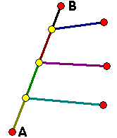
The A->B line will hardly be perfectly straight in softwares that forces you to stop the digitizing process at each node (marked with color circles). In MiraMon you just draw the A->B line by clicking in A and B and then connect to the appropriate points: A->B remains straight. A similar problem arises when working with map sheet boundaries: in MiraMon you simply draw a rectangle and then connect to it the inner boundaries; in other packages the sheet boundaries will never be straight: now imagine the problem when joining two map sheets with a frontier not perfectly straight.
You can also try, in most other softwares, to digitize two ovelapping polygons like:
 ==>
==> 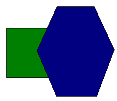
Since these softwares do not know how to build true arc/node topology, they will ignore the overlapped region unless you specifically interrupt your lines at nodes (marked with yellow cicles in the next figure).
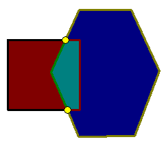
MiraMon will calculate them for you and lines will be perfectly straight when needed.
Another interesting capability of MiraMon is that you can have other vector layers in the display during the digitizing process. This is very useful because you can use them as a visual reference and even you can also copy their features to the current digitizing layer (which adds consistent geometry to your databases), keeping the original attribute of the copied feature if you wish (you will always know about the origin of each element: if it was a road, a river, a newly digitized one, etc). Of course these companion layers can be of any kind (polygons, arcs, points) and can be queried at any time during the digitizing process: you can copy a part of a road that will be a part of a polygon boundary. Of course, you do not need to copy all the objects from the reference layers to the destination layer, but only the needed ones. An extra interest of these layers is to use an adjacent sheet you digitized before to see at each moment where to connect the entities of the current sheet when they reach the boundary of this current sheet.
MiraMon supports multiple labels for the same polygon, wich is very useful for complex polygons, where you can doubt if it was already labelled; of course, if two labels are not consistent from the thematic point of view, you are warned about. Adding a new label does not require to rebuild topology because polygon geometry and topology is created in a previous, independent step, than polygon labelling.
Connecting elements in MiraMon (snap) is done by means of typical CAD tools, leaving tolerances at the last step of topology building: this is much more useful and less problematic than connecting using tolerances while digitizing because you have strict control about if you are connecting on a terminal vertex of a line, on an intermediate vertex or on a calculated point between two vertices.
MiraMon transparently works with its own raster and vector files, not needing to convert your backdrop rasters to other formats for digitizing. Moreover, backdrop rasters can be direct RGB, true 24-bit (16 milion color) images, which get composed by simply clicking the three bands you wish. You do not need to lose color quality by creating 8-bit (256 color) composites from your favorite RGB combinations.
Large images (for example 80 Mbyte) can be used in a very fast way. Vector layers can be really complex (ask your usual software about layers containing polygons of, for example, 42000 vertices and 500 holes and try to edit them).
The layers you digitize can be exported to the most popular GIS and CAD formats, being not necessary, for some of them, to rebuild topology.
Moreover, MiraMon supports multiple record labelling (i.e., 1 to many relationships). This means that, for instance, you can assign more than one record to the same polygon.
MiraMon is a product with 10 years of experience, more than 3000 users, inexpensive (Price information) and that integrates true vector and raster GIS in the same environment you digitize. You can even generate orthophotos from aerial photography and a Digital Elevation Model (DEM) and orthoimages from Landsat, Spot, etc and a DEM.