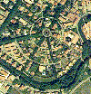
The MiraMon Map Reader
allows to visualize raster data (orthophotographies, thematic maps, digital elevation
models, ...), vector data (contour lines, topographic maps, ...) and alphanumerical
databases with links to any file type which can be opened from a Windows-based application
(e.g. spreadsheets, databases, sound and video files, URLs, ...).
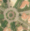
Data that are shown below are stored in the MMZ file format, which is the compression
format for MiraMon data. This file format allows a rapid download from
the internet (files forming a graphical layer are highly compressed in a single file). Once
the file is downloaded it is decompressed in the client computer without necessarily being
connected to internet.
A simple click
on the hyperlink to the MMZ files will show you the data with the MiraMon Map Reader.
You only need to have previously installed the
MiraMon Map Reader
|
Examples:
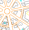
- Files of raster type (orthophotos, digital elevation
models, thematic rasters, etc)
- Topologically-structured vector data (inventory points, contour
lines, roads, land use polygons, etc).
- Tabular alphanumerical data.
- See the MiraMon Map Reader at work.
- Visit the web page of the
Department of the Environment of the Government of Catalonia. It contains base cartography for
all of Catalonia and many environmental graphical layers.
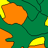
- LUCC CD-ROM Series. Nº1: Miombo Internet release
Many researchers are interested in global data or in data at continental scale.
The "LUCC CD-ROM Series. Nº1: Miombo" describes the south African zones forming
the Miombo region. This way, researchers of the area can access a huge
amount of information from a unified source. The CD-ROM, or the equivalent
Internet web site, integrates in a GIS: digital elevation models, administrative
boundaries, daily, monthly and gridded climate data, vegetation and
land use-land cover data, AVHRR images, population and socioeconomic
datasets, etc.
An Internet browser together with the "MiraMon Map Reader" GIS software
is used to easily access the CD-ROM data. (text based on the abstract presented on
the Proceedings of GIS PlaNET'98 International Conference and Exhibition on Geographic Information 7-11 September 1998. Lisbon - Portugal)
|